
Sherburne County topographic map
Interactive map
Click on the map to display elevation.
About this map
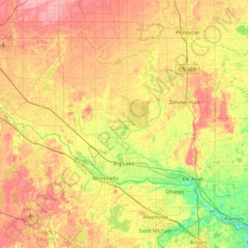
Name: Sherburne County topographic map, elevation, terrain.
Location: Sherburne County, Minnesota, United States (45.24573 -94.15051 45.55999 -93.50980)
Average elevation: 298 m
Minimum elevation: 254 m
Maximum elevation: 346 m
Other topographic maps
Click on a map to view its topography, its elevation and its terrain.
Minneapolis
United States > Minnesota > Hennepin County
Minneapolis, Hennepin County, Minnesota, United States
Average elevation: 270 m
Saint Paul
United States > Minnesota > Ramsey County
Saint Paul, Ramsey County, Minnesota, United States
Average elevation: 268 m
Bloomington
United States > Minnesota > Hennepin County
Bloomington, Hennepin County, Minnesota, United States
Average elevation: 255 m
Bucks Mill
United States > Minnesota > Becker County
Bucks Mill, Becker County, Minnesota, United States
Average elevation: 410 m
Big Moose Lake
United States > Minnesota > Saint Louis County
Big Moose Lake, Northeast St Louis, Saint Louis County, Minnesota, United States
Average elevation: 432 m
Minneapolis
United States > Minnesota > Hennepin County > Minneapolis
Minneapolis, Hennepin County, Minnesota, 55488, United States
Average elevation: 271 m
Maple Grove
United States > Minnesota > Hennepin County
Maple Grove, Hennepin County, Minnesota, United States
Average elevation: 278 m
Rochester
United States > Minnesota > Olmsted County
Rochester, Olmsted County, Minnesota, United States
Average elevation: 354 m
Duluth
United States > Minnesota > Saint Louis County
Duluth, Saint Louis County, Minnesota, United States
Average elevation: 286 m
Itasca County
Itasca County, Minnesota, United States
Average elevation: 412 m
Mankato
United States > Minnesota > Blue Earth County
Mankato, Blue Earth County, Minnesota, 56001, United States
Average elevation: 285 m
Olmsted County
Olmsted County, Minnesota, United States
Average elevation: 354 m
Crow Wing County
Crow Wing County, Minnesota, United States
Average elevation: 386 m
Eagan
United States > Minnesota > Dakota County
Eagan, Dakota County, Minnesota, United States
Average elevation: 267 m
Bonnevista Terrace Mobile Home Park
United States > Minnesota > Scott County
Bonnevista Terrace Mobile Home Park, Jackson Township, Scott County, Minnesota, United States
Average elevation: 241 m
Washington County
Washington County, Minnesota, United States
Average elevation: 283 m
Kittson County
Kittson County, Minnesota, United States
Average elevation: 275 m
Hills
United States > Minnesota > Rock County
Hills, Martin Township, Rock County, Minnesota, 56138, United States
Average elevation: 445 m
Green Lake
United States > Minnesota > Beltrami County > Little Rock
Green Lake, Little Rock, Beltrami County, Minnesota, United States
Average elevation: 379 m
Grey Cloud Island
United States > Minnesota > Washington County > Grey Cloud Island Township
Grey Cloud Island, Grey Cloud Island Township, Washington County, Minnesota, 55071, United States
Average elevation: 225 m
West St. Paul
United States > Minnesota > Dakota County
West St. Paul, Dakota County, Minnesota, 55118, United States
Average elevation: 294 m
Bemidji
United States > Minnesota > Beltrami County
Bemidji, Beltrami County, Minnesota, 56601, United States
Average elevation: 417 m
Dunnell
United States > Minnesota > Martin County
Dunnell, Martin County, Minnesota, United States
Average elevation: 403 m
Gainy Park
United States > Minnesota > Steele County > Owatonna
Gainy Park, Owatonna, Steele County, Minnesota, United States
Average elevation: 359 m
Glendale
United States > Minnesota > Scott County > Savage
Glendale, Savage, Scott County, Minnesota, 55378, United States
Average elevation: 262 m
Stillwater
United States > Minnesota > Washington County
Stillwater, Washington County, Minnesota, United States
Average elevation: 259 m
Big Deep Lake
United States > Minnesota > Cass County
Big Deep Lake, Cass County, Minnesota, United States
Average elevation: 420 m
Bodum
United States > Minnesota > Isanti County
Bodum, Isanti Township, Isanti County, Minnesota, 55008, United States
Average elevation: 294 m
Oxlip
United States > Minnesota > Isanti County
Oxlip, Bradford Township, Isanti County, Minnesota, United States
Average elevation: 288 m
Minnetonka
United States > Minnesota > Hennepin County
Minnetonka, Hennepin County, Minnesota, United States
Average elevation: 290 m
Crown
United States > Minnesota > Isanti County
Crown, Stanford Township, Isanti County, Minnesota, United States
Average elevation: 295 m
Weber
United States > Minnesota > Isanti County
Weber, North Branch Township, Isanti County, Minnesota, United States
Average elevation: 282 m
Walbo
United States > Minnesota > Isanti County
Walbo, Springvale Township, Isanti County, Minnesota, United States
Average elevation: 286 m
Springvale
United States > Minnesota > Isanti County
Springvale, Springvale Township, Isanti County, Minnesota, United States
Average elevation: 288 m
Pine Brook
United States > Minnesota > Isanti County
Pine Brook, Springvale Township, Isanti County, Minnesota, United States
Average elevation: 291 m
Grandy
United States > Minnesota > Isanti County
Grandy, Cambridge Township, Isanti County, Minnesota, 55029, United States
Average elevation: 285 m
Elm Park
United States > Minnesota > Isanti County
Elm Park, Maple Ridge Township, Isanti County, Minnesota, United States
Average elevation: 290 m
Carmody
United States > Minnesota > Isanti County
Carmody, Dalbo Township, Isanti County, Minnesota, 55017, United States
Average elevation: 299 m
Stanchfield
United States > Minnesota > Isanti County
Stanchfield, Stanchfield Township, Isanti County, Minnesota, 55080, United States
Average elevation: 287 m
Wyanett
United States > Minnesota > Isanti County
Wyanett, Wyanett Township, Isanti County, Minnesota, United States
Average elevation: 293 m
West Point
United States > Minnesota > Isanti County
West Point, Spencer Brook Township, Isanti County, Minnesota, United States
Average elevation: 287 m
Stanley
United States > Minnesota > Isanti County
Stanley, Isanti Township, Isanti County, Minnesota, United States
Average elevation: 293 m
Stanchfield Corner
United States > Minnesota > Isanti County
Stanchfield Corner, Stanchfield Township, Isanti County, Minnesota, 55080, United States
Average elevation: 287 m
Spring Lake
United States > Minnesota > Isanti County
Spring Lake, North Branch Township, Isanti County, Minnesota, United States
Average elevation: 286 m
Spencer Brook
United States > Minnesota > Isanti County
Spencer Brook, Spencer Brook Township, Isanti County, Minnesota, United States
Average elevation: 289 m
Edgewood
United States > Minnesota > Isanti County
Edgewood, Isanti Township, Isanti County, Minnesota, 55008, United States
Average elevation: 289 m
Day
United States > Minnesota > Isanti County
Day, Maple Ridge Township, Isanti County, Minnesota, United States
Average elevation: 302 m
Dalbo
United States > Minnesota > Isanti County
Dalbo, Dalbo Township, Isanti County, Minnesota, 55017, United States
Average elevation: 296 m
Blomford
United States > Minnesota > Isanti County
Blomford, Isanti Township, Isanti County, Minnesota, United States
Average elevation: 290 m