
Make a donation
Crow Wing County topographic map
Click on the map to display elevation.
Make a donation
Crow Wing County
Crow Wing County features a diverse and dynamic topography characterized primarily by its rolling hills, numerous lakes, and the scenic landscapes shaped by glacial activity. The region is part of the Central Lowlands physiographic province, which predominantly consists of gently undulating terrain that slopes towards the Mississippi River and its tributaries. Elevations range from about 1,500 feet in the western parts to lower elevations near the lakes and river valleys. The county's land is dotted with more than 500 lakes, including the popular Gull Lake, which contributes to its picturesque scenery and recreational opportunities. Forested areas, comprising a mix of hardwoods and conifers, provide a rich ecological habitat, while the underlying geology, shaped by ancient glacial processes, gives rise to fertile soils that are ideal for both agriculture and natural vegetation.
Make a donation
About this map
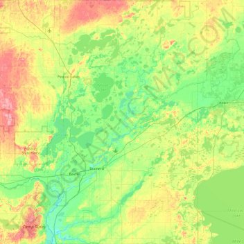
Name: Crow Wing County topographic map, elevation, terrain.
Location: Crow Wing County, Minnesota, United States (46.15592 -94.39572 46.80553 -93.77602)
Average elevation: 386 m
Minimum elevation: 347 m
Maximum elevation: 471 m
Make a donation
Other topographic maps
Click on a map to view its topography, its elevation and its terrain.
Moody Lake
United States > Minnesota > Chisago County > Chisago Lake Township
Average elevation: 283 m
Make a donation
Elm Creek Park (Maple Grove Arboretum)
United States > Minnesota > Hennepin County > Maple Grove
Average elevation: 278 m
Echo River
United States > Minnesota > Saint Louis County > Northeast St Louis
Average elevation: 393 m
Make a donation
Make a donation
Rum River North County Park
United States > Minnesota > Anoka County > Saint Francis
Average elevation: 279 m
Make a donation
Central Lakes
United States > Minnesota > Saint Louis County > Ellsburg Township
Average elevation: 408 m
Spencer Lake
United States > Minnesota > Meeker County > Collinwood Township > Jennie
Average elevation: 334 m
Make a donation
Middle Cullen Lake
United States > Minnesota > Crow Wing County > Pequot Lakes
Average elevation: 372 m
Mississippi River
United States > Minnesota > Hennepin County > Minneapolis
The uppermost lock and dam on the Upper Mississippi River is the Upper St. Anthony Falls Lock and Dam in Minneapolis. Above the dam, the river's elevation is 799 feet (244 m). Below the dam, the river's elevation is 750 feet (230 m). This 49-foot (15 m) drop is the largest of all the Mississippi River locks…
Average elevation: 256 m
Make a donation
Make a donation
St. Croix River Boom Site Landing
United States > Minnesota > Washington County > Stillwater Township
Average elevation: 253 m
Make a donation
Pearl Lake
United States > Minnesota > Stearns County > Maine Prairie Township
Average elevation: 343 m
Make a donation
Countryside Mobile Home Park
United States > Minnesota > Pennington County > Thief River Falls
Average elevation: 344 m
Make a donation
Chris Lake
United States > Minnesota > Saint Louis County > Pequaywan Township
Average elevation: 494 m
Make a donation
Embarrass
United States > Minnesota > Saint Louis County > Embarrass Township
Average elevation: 438 m
Make a donation
Make a donation
Ancient River Warren Channel (historical)
United States > Minnesota > Traverse County
Average elevation: 300 m
Ford Dam Scenic Overlook
United States > Minnesota > Ramsey County > Saint Paul
Average elevation: 251 m
Make a donation
Make a donation
Make a donation
Riverbend Estates
United States > Minnesota > Nicollet County > North Mankato
Average elevation: 265 m
Make a donation
Make a donation
Sungold Heights Mobile Home Park
United States > Minnesota > Nobles County > Worthington
Average elevation: 482 m
Make a donation
Make a donation
Make a donation
Grey Cloud Island
United States > Minnesota > Washington County > Grey Cloud Island Township
Average elevation: 225 m
Make a donation
Make a donation
Natalie Webb Familly Aquatic Center
United States > Minnesota > Dodge County > Dodge Center > Valley View Park
Average elevation: 384 m
Make a donation
Twin Pine Mobile Home Park
United States > Minnesota > Washington County > Hugo
Average elevation: 282 m
Make a donation