
Matabeleland South Province topographic map
Interactive map
Click on the map to display elevation.
About this map
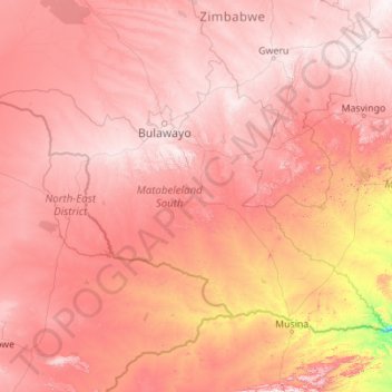
Name: Matabeleland South Province topographic map, elevation, terrain.
Location: Matabeleland South Province, Zimbabwe (-22.35634 26.70225 -19.48322 31.12130)
Average elevation: 959 m
Minimum elevation: 227 m
Maximum elevation: 1,597 m
Other topographic maps
Click on a map to view its topography, its elevation and its terrain.
Marondera
Zimbabwe > Mashonaland East Province > Marondera
Marondera, Mashonaland East Province, Zimbabwe
Average elevation: 1,637 m
Rusape
Zimbabwe > Manicaland Province > Makoni
Rusape, Makoni, Manicaland Province, Zimbabwe
Average elevation: 1,415 m
Hwange
Hwange, Matabeleland North, 00236, Zimbabwe
Average elevation: 968 m
Lake Chivero
Lake Chivero, Kamba Caravan Park Acces Road, Zvimba, Mashonaland West, Zimbabwe
Average elevation: 1,382 m
Victoria Falls National Park
Zimbabwe > Matabeleland North > Victoria Falls
Victoria Falls National Park, Pioneer Road, Victoria Falls, Hwange, Matabeleland North, 00236, Zimbabwe
Average elevation: 913 m
Mount Nyangani
Mount Nyangani, Nyanga, Manicaland, Zimbabwe
Average elevation: 2,329 m