
Kok River topographic map
Interactive map
Click on the map to display elevation.
About this map
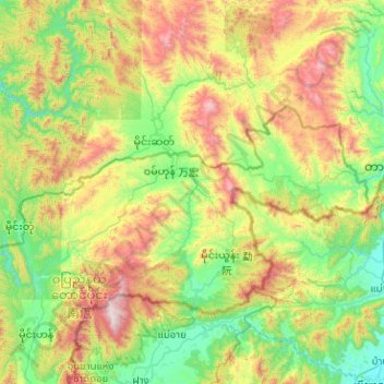
Name: Kok River topographic map, elevation, terrain.
Location: Kok River, Wa State, Myanmar (19.91189 99.25748 20.86062 100.14409)
Average elevation: 895 m
Minimum elevation: 381 m
Maximum elevation: 2,237 m
Other topographic maps
Click on a map to view its topography, its elevation and its terrain.
Pyin Oo Lwin
Pyin Oo Lwin or Pyin U Lwin (Burmese: ပြင်ဦးလွင်မြို့; MLCTS: prang u: lwang mrui., pronounced [pjɪ̀ɰ̃ ʔú lwɪ̀ɰ̃]; Shan: ဝဵင်းပၢင်ႇဢူႈ, Weng Pang U), formerly and colloquially referred to as Maymyo (Burmese: မေမြို့; MLCTS: me…
Average elevation: 913 m
Kalaw
Myanmar > Shan State > Kalaw District
The hill station is located at an elevation of 1310 metres, 50 km from the Inle lake. Kalaw is famous for hiking and trekking. Many trekking trails ranging from nearby places to Inle Lake and Pindaya. The town still feels like a high-altitude holiday resort – the air is cool, the atmosphere is calm and the…
Average elevation: 1,366 m
Taunggyi
Myanmar > Shan State > Taunggyi District
Taunggyi (Burmese: တောင်ကြီးမြို့; MLCTS: taung kri: mrui. [tàʊɰ̃dʑí mjo̰]; Shan: ဝဵင်းတူၼ်ႈတီး ဝဵင်းလူင်တႆးႁဝ်း Shan pronunciation: [weŋ˥ ton˧˧˨ ti˥]; Pa'O language : ဝေင်ꩻတောင်ႏကီꩻ…
Average elevation: 1,151 m
Pyin Oo Lwin
Pyin Oo Lwin or Pyin U Lwin (Burmese: ပြင်ဦးလွင်မြို့; MLCTS: prang u: lwang mrui., pronounced [pjɪ̀ɰ̃ ʔú lwɪ̀ɰ̃]; Shan: ဝဵင်းပၢင်ႇဢူႈ), formerly and colloquially referred to as Maymyo (Burmese: မေမြို့; MLCTS: me mrui.), is a…
Average elevation: 913 m
Taungoo
Myanmar > Bago Region > Taungoo District
Three mountain ranges traverse the district—the Pegu Yomas, the Karen Hills, and the Nat Ma Taung or "Great Watershed"—all of which have a north and south direction, and are covered for the most part with dense forest. The Pegu Yomas have a general elevation of from 800 to 1,200 feet (240 to 370 m), while…
Average elevation: 76 m
Kalaw
Myanmar > Shan State > Kalaw Township
The hill station is located at an elevation of 1310 metres, 50 km from the Inle lake. Kalaw is famous for hiking and trekking. Many trekking trails ranging from nearby places to Inle Lake and Pindaya. The town still feels like a high-altitude holiday resort – the air is cool, the atmosphere is calm and the…
Average elevation: 1,348 m
Taunggyi
Myanmar > Shan State > Taunggyi District
Taunggyi (Burmese: တောင်ကြီးမြို့; MLCTS: taung kri: mrui. [tàʊɰ̃dʑí mjo̰]; Shan: ဝဵင်းတူၼ်ႈတီး [weŋ˥ ton˧˧˨ ti˥]; Pa'O: ဝေင်ꩻတောင်းကီꩻ) is the capital and largest city of Shan State, Myanmar (Burma) and lies on the…
Average elevation: 1,149 m
Zay Kone စျေးကုန်း
Myanmar > Mandalay > Kyaukse District > Myittha Township > Zay Kone စျေးကုန်း
Average elevation: 100 m
Ayeyarwaddy International School
Myanmar > Mandalay > Mandalay District > Mandalay > Chanayethazan Township
Average elevation: 78 m
Aungpan
Myanmar > Shan State > Aungpan
Aungpan (Burmese: အောင်ပန်းမြို့) is a town located in the Southern Shan State. It is located in Kalaw Township which is part of Taunggyi District. It lies on the Thazi-Kyaingtong road at an elevation of 4219 feet (1286 meters) above sea level.
Average elevation: 1,329 m