
紫溪乡 topographic map
Interactive map
Click on the map to display elevation.
About this map
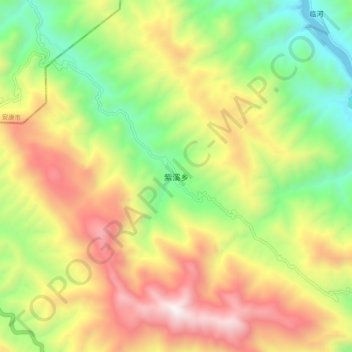
Name: 紫溪乡 topographic map, elevation, terrain.
Location: 紫溪乡, 万源市, 达州市, Sichuan, China (32.17047 108.18424 32.25047 108.26424)
Average elevation: 1,189 m
Minimum elevation: 427 m
Maximum elevation: 2,125 m
Other topographic maps
Click on a map to view its topography, its elevation and its terrain.
འབར་ཁམས་རྫོང་ 马尔康市
འབར་ཁམས་རྫོང་ 马尔康市, 阿坝藏族羌族自治州, Sichuan, China
Average elevation: 3,858 m
银多乡
China > Sichuan > ཉག་རོང་རྫོང་ 新龙县
银多乡, ཉག་རོང་རྫོང་ 新龙县, 甘孜藏族自治州, Sichuan, China
Average elevation: 4,340 m