
Make a donation
Canada topographic map
Click on the map to display elevation.
Make a donation
Canada
Canada's topography is a diverse tapestry shaped by its vast landscapes and geological history. Dominating nearly half of the country, the Canadian Shield is a massive expanse of ancient, eroded rocks, characterized by a rugged terrain dotted with countless lakes and rivers. To the west, the majestic Rocky Mountains rise sharply, featuring some of the nation's highest peaks and deep valleys carved by glacial activity. In contrast, the central provinces are home to the Interior Plains, expansive flatlands that stretch between the Shield and the Rockies, known for their fertile soils and prairie landscapes. The eastern region encompasses the Appalachian Mountains, an older and more eroded range presenting rolling hills and rich forests. Along the southern edge, the Great Lakes–St. Lawrence Lowlands offer fertile plains that support a significant portion of Canada's agriculture and urban development. In the far north, the Arctic Archipelago consists of a labyrinth of islands and peninsulas, characterized by permafrost and tundra, presenting a stark yet captivating landscape. This intricate blend of mountains, plains, forests, and tundra defines Canada's varied terrain.
Make a donation
About this map
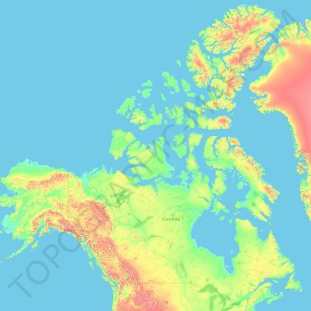
Name: Canada topographic map, elevation, terrain.
Location: Canada (41.67656 -141.00275 83.33621 -52.32377)
Average elevation: 254 m
Minimum elevation: -2 m
Maximum elevation: 4,944 m
Make a donation
Other topographic maps
Click on a map to view its topography, its elevation and its terrain.
Make a donation
Make a donation
Addis Ababa
Ethiopia > Addis Ababa > Arada
Addis Ababa (/ˌædɪs ˈæbəbə/ AD-iss AB-ə-bə; Amharic: አዲስ አበባ [adˈdis ˈaβəβa] , lit. 'new flower'; Oromo: Finfinnee, lit. 'fountain of hot mineral water') is the capital city of Ethiopia. With an estimated population of 2,739,551 inhabitants as of the 2007 census, it is the largest…
Average elevation: 2,517 m
Make a donation
Kotdwar
India > Uttarakhand > Kotdwara
Kotdwar lies on the western margin of the Himalayas, at an altitude of 454 m (1,490 ft) above sea level.
Average elevation: 641 m
Make a donation
Sinabad
Iran > West Azerbaijan Province > Urumia County > دهستان صومای جنوبی
Average elevation: 1,876 m
Make a donation
Aramoun
Lebanon > Mount Lebanon Governorate
Aramoun (Arabic: عرمون) is a village in the Aley District of Mount Lebanon, Lebanon, lying to the east of Khalde and 22 kilometres away from Beirut. Aramoun's altitude ranges between 250 meters to 600 meters further east. The village has a Druze and Christian community, major families are Yehia, Jawhari,…
Average elevation: 467 m
Make a donation
Corró d'Amunt
Spain > Catalonia > Vallès Oriental > les Franqueses del Vallès
Average elevation: 287 m
Make a donation
Make a donation
Pièce du Moulin
France > Nouvelle-Aquitaine > Charente-Maritime > Le Grand-Village-Plage
Average elevation: 4 m
Make a donation
Make a donation
Make a donation
Make a donation
Make a donation
Sungai Haji Dorani
Malaysia > Selangor > Kampung Sungai Haji Dorani > Kampung Nelayan Sungai Haji Durani
Average elevation: 3 m
Make a donation
Bayang
The topography of the municipality is generally characterized by moderately sloping lands. Approximately 2,606 hectares (63.45%) have moderate slopes of 8 – 15%. Steep lands with a slope 40 – 60% comprise 20.14% (827) ha. About 674 (16.41) have nearly level terrain.
Average elevation: 782 m
Make a donation
San Jose
The municipality is in a valley bounded on the east by the Palusong Mountain Range moving south and on the west by the Hitaasan Mountain Range. The land is generally alluvial flat and swamplands which has an elevation of less than 10 metres (33 ft) above sea level, while going south, south easterly, the…
Average elevation: 15 m
Make a donation
Make a donation
Make a donation
Make a donation
Make a donation
Johannesburg
South Africa > Gauteng > City of Johannesburg Metropolitan Municipality
Johannesburg is located in the eastern plateau area of South Africa known as the Highveld, at an elevation of 1,753 metres (5,751 ft). The former Central Business District is located on the southern side of the prominent ridge called the Witwatersrand (English: White Water's Ridge) and the terrain falls to the…
Average elevation: 1,615 m
Lindridge Park
United Kingdom > England > Devon > Teignbridge > Luton > Humber
Average elevation: 125 m
Make a donation
Sudeley Castle
United Kingdom > England > Gloucestershire > Cheltenham > Sudeley
His elevation almost certainly came from his assistance in the suppression of the Wyatt rebellion.
Average elevation: 135 m
Αβία
Greece > Peloponnese Region > Messenia Regional Unit > Municipal Unit of Avia
Average elevation: 45 m
Make a donation
Make a donation
Worsbrough
United Kingdom > England > Barnsley
On High Street, Worsbrough Dale. The east elevation bears the inscriptions "AD 1903" and "Ebenezer Wesleyan Reform". There are also foundation stones either side of the doorway inscribed with "EBENEZER CHAPEL 1854". This suggests that the chapel was built in 1854 and extended upwards in 1903.
Average elevation: 98 m
Make a donation
Le Plan de l'Envers
France > Auvergne-Rhône-Alpes > Upper Savoy > Vallorcine
Average elevation: 1,721 m
Kampos Marathokampou
Greece > Northern Aegean > Samos Regional Unit > Municipal Unit of Marathokabos
Average elevation: 99 m
Make a donation