
Wanica topographic map
Interactive map
Click on the map to display elevation.
About this map
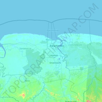
Name: Wanica topographic map, elevation, terrain.
Location: Wanica, Suriname (5.05000 -55.95000 6.45000 -54.55000)
Average elevation: 11 m
Minimum elevation: -4 m
Maximum elevation: 361 m
Other topographic maps
Click on a map to view its topography, its elevation and its terrain.
Koewarasan
Suriname > Wanica > Wanica > Koewarasan
Koewarasan, Wanica, +597, Suriname
Average elevation: 5 m