
Thank you for supporting this site ❤️
Make a donation
Make a donation
Niiza topographic map
Click on the map to display elevation.
Thank you for supporting this site ❤️
Make a donation
Make a donation
About this map
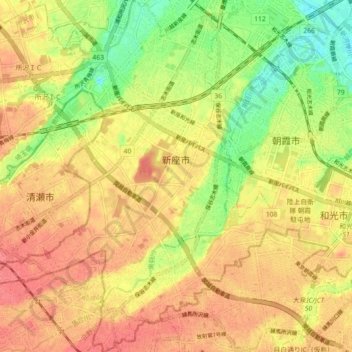
Name: Niiza topographic map, elevation, terrain.
Location: Niiza, Saitama Prefecture, Japan (35.75338 139.51637 35.82582 139.59414)
Average elevation: 38 m
Minimum elevation: 1 m
Maximum elevation: 62 m
Thank you for supporting this site ❤️
Make a donation
Make a donation
Other topographic maps
Click on a map to view its topography, its elevation and its terrain.
Mount Yōtei
Japan > Abuta County > Kutchan
In the 50,000:1 scale topographical map of the “Rusutsu” area published in 1920 by Japan’s Land Surveying Department, the mountain is recorded as "Shiribeshi-Yōtei-zan (Ezo-Fuji)". However, since the name was difficult to read, the town of Kutchan asked for it to be changed to Yōtei-zan. The change…
Average elevation: 1,395 m
Thank you for supporting this site ❤️
Make a donation
Make a donation