
Make a donation
Nikko topographic map
Click on the map to display elevation.
Make a donation
About this map
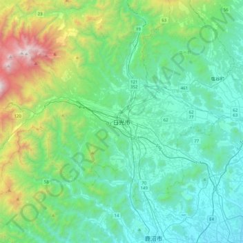
Name: Nikko topographic map, elevation, terrain.
Location: Nikko, Nikkō, Tochigi Prefecture, 321-1271, Japan (36.56146 139.53342 36.88146 139.85342)
Average elevation: 581 m
Minimum elevation: 116 m
Maximum elevation: 2,442 m
Make a donation
Other topographic maps
Click on a map to view its topography, its elevation and its terrain.
Hokkaido Prefecture
As Japan's coldest region, Hokkaidō has relatively cool summers and icy/snowy winters. Most of the island falls in the humid continental climate zone with Köppen climate classification Dfb (hemiboreal) in most areas but Dfa (hot summer humid continental) in some inland lowlands. The average August…
Average elevation: 81 m
Ise
Ise is located on the northern half of Shima Peninsula in far eastern Mie Prefecture. The northern part of the city is flat land and faces Ise Bay on the Pacific Ocean. In the south, the land rises to form hills and mountains with an elevation of 100 to 500 meters. Most of the city is within the geographic…
Average elevation: 52 m
Make a donation
Make a donation
Make a donation
Yakushima
The bedrock of the island is granite, and as such it hosts no active volcanoes. It has an area of approximately 504.5 square kilometres (194.8 sq mi). The island is roughly circular in shape, with a circumference of 89 kilometres (55 mi) and a diameter of 28 kilometres (17 mi). The highest elevations on the…
Average elevation: 401 m
Utsunomiya
Utsunomiya is located in south-central Tochigi Prefecture in the northern Kantō plains. It is approximately 100 km (60 mi) north of Tokyo. The historic town of Nikkō is approximately 25 km (15 mi) northwest of Utsunomiya. The average elevation of the city is 100 metres (330 ft).
Average elevation: 161 m
Make a donation
Fukushima Prefecture
Fukushima city is located in the Fukushima Basin's southwest area and nearby mountains. Located on the central eastern seaboard a part of the Pacifim rim. A region with high tectonic activity given its location where the Pacific and Eurasian continental plates collide - a part the Ring of Fire. " Aizuwakamatsu…
Average elevation: 402 m
Make a donation
Sendai
Sendai is located at lat. 38°16'05" north, long. 140°52'11" east. The city's area is 788.09 km2 (304.28 sq mi), and stretches from the Pacific Ocean to the Ōu Mountains, which are the east and west borders of Miyagi Prefecture. As a result, the city's geography is quite diverse. Eastern Sendai is a plains…
Average elevation: 185 m
Make a donation
Make a donation
Koto
Kōtō occupies a position on the waterfront of Tokyo Bay sandwiched between the wards of Chūō and Edogawa. Its inland boundary is with Sumida. Much of the land is reclaimed, The northern part is old reclaimed land, and the elevation is very low(below sea level. The southern part is relatively new, but…
Average elevation: 5 m
Make a donation