
Make a donation
Koto topographic map
Click on the map to display elevation.
Make a donation
Koto
Kōtō occupies a position on the waterfront of Tokyo Bay sandwiched between the wards of Chūō and Edogawa. Its inland boundary is with Sumida. Much of the land is reclaimed, The northern part is old reclaimed land, and the elevation is very low(below sea level. The southern part is relatively new, but there are few old temples or shrines.
Make a donation
About this map
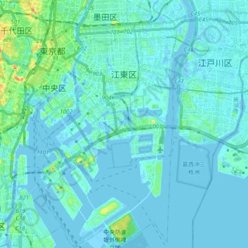
Name: Koto topographic map, elevation, terrain.
Location: Koto, Tokyo, Japan (35.58865 139.76672 35.70809 139.84854)
Average elevation: 5 m
Minimum elevation: -10 m
Maximum elevation: 52 m
Make a donation
Other topographic maps
Click on a map to view its topography, its elevation and its terrain.
Mount Yōtei
Japan > Abuta County > Kutchan
In the 50,000:1 scale topographical map of the “Rusutsu” area published in 1920 by Japan’s Land Surveying Department, the mountain is recorded as "Shiribeshi-Yōtei-zan (Ezo-Fuji)". However, since the name was difficult to read, the town of Kutchan asked for it to be changed to Yōtei-zan. The change…
Average elevation: 1,395 m
Make a donation