
Ise topographic map
Click on the map to display elevation.
Ise
Ise is located on the northern half of Shima Peninsula in far eastern Mie Prefecture. The northern part of the city is flat land and faces Ise Bay on the Pacific Ocean. In the south, the land rises to form hills and mountains with an elevation of 100 to 500 meters. Most of the city is within the geographic limits of Ise-Shima National Park.
About this map
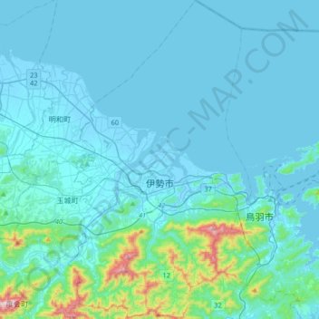
Name: Ise topographic map, elevation, terrain.
Location: Ise, Mie Prefecture, 516-0037, Japan (34.38472 136.63261 34.65348 136.82099)
Average elevation: 52 m
Minimum elevation: -5 m
Maximum elevation: 589 m
Other topographic maps
Click on a map to view its topography, its elevation and its terrain.
Mount Yōtei
Japan > Abuta County > Kutchan
In the 50,000:1 scale topographical map of the “Rusutsu” area published in 1920 by Japan’s Land Surveying Department, the mountain is recorded as "Shiribeshi-Yōtei-zan (Ezo-Fuji)". However, since the name was difficult to read, the town of Kutchan asked for it to be changed to Yōtei-zan. The change…
Average elevation: 1,395 m