
Thank you for supporting this site ❤️
Make a donation
Make a donation
Yuma topographic map
Click on the map to display elevation.
Thank you for supporting this site ❤️
Make a donation
Make a donation
About this map
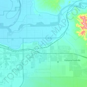
Name: Yuma topographic map, elevation, terrain.
Location: Yuma, Yuma County, Arizona, United States (32.65240 -114.65904 32.72622 -114.46608)
Average elevation: 78 m
Minimum elevation: 38 m
Maximum elevation: 477 m
Thank you for supporting this site ❤️
Make a donation
Make a donation
Other topographic maps
Click on a map to view its topography, its elevation and its terrain.