
Province of Ilo topographic map
Interactive map
Click on the map to display elevation.
About this map
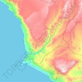
Name: Province of Ilo topographic map, elevation, terrain.
Location: Province of Ilo, Moquegua, Peru (-17.82148 -71.49080 -17.25172 -70.90717)
Average elevation: 652 m
Minimum elevation: 0 m
Maximum elevation: 1,803 m
Other topographic maps
Click on a map to view its topography, its elevation and its terrain.
Quellaveco
Quellaveco, Torata, Province of Mariscal Nieto, Moquegua, Peru
Average elevation: 3,861 m
Yurac Kancha
Yurac Kancha, Ubinas, Province of General Sánchez Cerro, Moquegua, Peru
Average elevation: 4,514 m
Toquepala Caves
Toquepala Caves, Carretera Moquegua - Toquepala, Moquegua, Province of Mariscal Nieto, Moquegua, Peru
Average elevation: 2,258 m
Pasto Grande
Pasto Grande, Carumas, Mariscal Nieto, Moquegua, Peru
Average elevation: 4,550 m
Los Cerrillos
Peru > Moquegua > Los Cerrillos
Los Cerrillos, Mariscal Nieto, Moquegua, Peru
Average elevation: 1,526 m