
Make a donation
Reading topographic map
Click on the map to display elevation.
Make a donation
Reading
Jane Austen attended Reading Ladies Boarding School, based in the Abbey Gateway, in 1784–1786. Mary Russell Mitford lived in Reading for a number of years and then spent the rest of her life just outside the town at Three Mile Cross and Swallowfield. The fictional Belford Regis of her eponymous novel, first published in 1835, is largely based on Reading. Described with topographical accuracy, it is still possible to follow the steps of the novel's characters in present-day Reading. Reading also appears in the works of Thomas Hardy where it is called 'Aldbrickham'. It features most heavily in his final novel, Jude the Obscure, as the temporary home of Jude Fawley and Sue Bridehead.
Make a donation
About this map
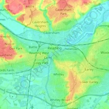
Name: Reading topographic map, elevation, terrain.
Location: Reading, England, United Kingdom (51.40975 -1.05299 51.49313 -0.92849)
Average elevation: 54 m
Minimum elevation: 32 m
Maximum elevation: 104 m
Make a donation
Other topographic maps
Click on a map to view its topography, its elevation and its terrain.
Make a donation
Make a donation
Wilstone Reservoir
United Kingdom > England > Hertfordshire > Dacorum > Wilstone
Average elevation: 110 m
Make a donation
Reigate
United Kingdom > England > Surrey > Reigate and Banstead
Reigate is in central Surrey, around 19 mi (30 km) south of central London and 9 mi (14 km) north of Gatwick Airport. The town is in the Vale of Holmesdale, below the North Downs escarpment. The average elevation in the centre is 80 m (260 ft) above ordnance datum (OD) and the area is drained by the Wallace…
Average elevation: 100 m
Make a donation
Make a donation
Make a donation
Bury Hey Wood
United Kingdom > England > Lancashire > West Lancashire > Appley Bridge > Robin Hood
Average elevation: 106 m
Gibsmere
United Kingdom > England > Nottinghamshire > Newark and Sherwood > Bleasby
Average elevation: 30 m
Make a donation
Swindon
United Kingdom > England > Swindon
Swindon has an oceanic climate (Cfb in the Köppen climate classification), like the vast majority of the British Isles, with cool winters and warm summers. The nearest official weather station is RAF Lyneham, about 10 miles (16 km) west southwest of Swindon town centre. The weather station's elevation is 145…
Average elevation: 108 m
Make a donation
Fleet Hargate
United Kingdom > England > Lincolnshire > South Holland > Fleet Hargate
Average elevation: 3 m
Make a donation