
Thank you for supporting this site ❤️
Make a donation
Make a donation
Bruceton Mills topographic map
Click on the map to display elevation.
Thank you for supporting this site ❤️
Make a donation
Make a donation
About this map
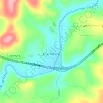
Name: Bruceton Mills topographic map, elevation, terrain.
Location: Bruceton Mills, Preston County, West Virginia, United States (39.65756 -79.64287 39.66102 -79.63798)
Average elevation: 508 m
Minimum elevation: 458 m
Maximum elevation: 601 m
Thank you for supporting this site ❤️
Make a donation
Make a donation
Other topographic maps
Click on a map to view its topography, its elevation and its terrain.
Thank you for supporting this site ❤️
Make a donation
Make a donation
Thank you for supporting this site ❤️
Make a donation
Make a donation