
Thank you for supporting this site ❤️
Make a donation
Make a donation
Kulim topographic map
Click on the map to display elevation.
Thank you for supporting this site ❤️
Make a donation
Make a donation
About this map
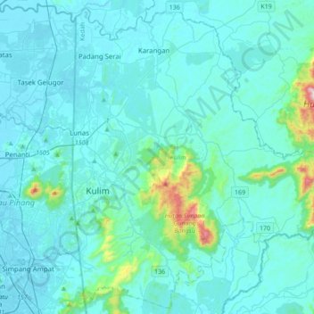
Name: Kulim topographic map, elevation, terrain.
Location: Kulim, Kedah, Malaysia (5.23902 100.52410 5.56672 100.86640)
Average elevation: 65 m
Minimum elevation: 0 m
Maximum elevation: 778 m
Thank you for supporting this site ❤️
Make a donation
Make a donation
Other topographic maps
Click on a map to view its topography, its elevation and its terrain.
Thank you for supporting this site ❤️
Make a donation
Make a donation
Thank you for supporting this site ❤️
Make a donation
Make a donation