
Suffolk County topographic map
Interactive map
Click on the map to display elevation.
About this map
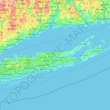
Name: Suffolk County topographic map, elevation, terrain.
Location: Suffolk County, New York, United States (40.55525 -73.54748 41.31050 -71.79557)
Average elevation: 36 m
Minimum elevation: -3 m
Maximum elevation: 399 m
The highest elevation in the county, and on Long Island as a whole, is Jayne's Hill in West Hills, at 401 feet (122 m) above sea level.
Other topographic maps
Click on a map to view its topography, its elevation and its terrain.
Town of Plattekill
United States > New York > Ulster County
Town of Plattekill, Ulster County, New York, United States
Average elevation: 162 m
Town of Ticonderoga
United States > New York > Essex County
Town of Ticonderoga, Essex County, New York, 12883, United States
Average elevation: 169 m
Hoffmeister
United States > New York > Hamilton County
Hoffmeister, Town of Morehouse, Hamilton County, New York, 13353, United States
Average elevation: 601 m
Hamilton County
Hamilton County, New York, United States
Average elevation: 574 m
Armonk
United States > New York > Westchester County
Armonk, Town of North Castle, Westchester County, New York, 10504, United States
Average elevation: 156 m
Town of Arietta
United States > New York > Hamilton County
Town of Arietta, Hamilton County, New York, United States
Average elevation: 599 m
Bouckville
United States > New York > Madison County
Bouckville, Town of Madison, Madison County, New York, 13310, United States
Average elevation: 393 m
Arctic
United States > New York > Delaware County > Town of Masonville
Arctic, Town of Masonville, Delaware County, New York, United States
Average elevation: 558 m
Village of Black River
United States > New York > Jefferson County
Village of Black River, Town of Le Ray, Jefferson County, New York, United States
Average elevation: 193 m
Village of Delhi
United States > New York > Delaware County
Village of Delhi, Town of Delhi, Delaware County, New York, United States
Average elevation: 526 m
Bloomville
United States > New York > Delaware County
Bloomville, Town of Kortright, Delaware County, New York, United States
Average elevation: 519 m
Shelter Island
United States > New York > Suffolk County
Shelter Island, Town of Shelter Island, Suffolk County, New York, United States
Average elevation: 4 m
Town of Smithtown
United States > New York > Suffolk County
Town of Smithtown, Suffolk County, New York, United States
Average elevation: 21 m
Waverly Glen Park
United States > New York > Tioga County > Waverly
Waverly Glen Park, Waverly, Town of Barton, Tioga County, New York, United States
Average elevation: 295 m
Town of Wallkill
United States > New York > Orange County
Town of Wallkill, Orange County, New York, United States
Average elevation: 171 m
Heath Grove
United States > New York > Town of Otisco > Heath Grove
Heath Grove, Town of Otisco, Onondaga County, New York, 13110, United States
Average elevation: 294 m
Newtonville
United States > New York > Town of Colonie > Newtonville
Newtonville, Town of Colonie, Albany County, New York, 12128, United States
Average elevation: 97 m
West Bangor
United States > New York > West Bangor
West Bangor, Franklin County, New York, 12966, United States
Average elevation: 232 m
New York County
United States > New York > New York
New York County, New York, United States
Average elevation: 16 m