
Make a donation
Baltimore County topographic map
Click on the map to display elevation.
Make a donation
Baltimore County
According to the United States Census Bureau, the county covers 682 square miles (1,770 km2), of which 598 square miles (1,550 km2) are land and 83 square miles (210 km2) (12%) are water. It is the third-largest county in Maryland by land area. The larger portion of the terrain is undulating, with bold hills often rising to a height of 800 feet (240 m) above tide water. The highest elevation is approximately 960 feet (290 m) above sea level, along the Pennsylvania state line near Steltz. The lowest elevation is sea level along the shoreline of Chesapeake Bay.
Make a donation
About this map
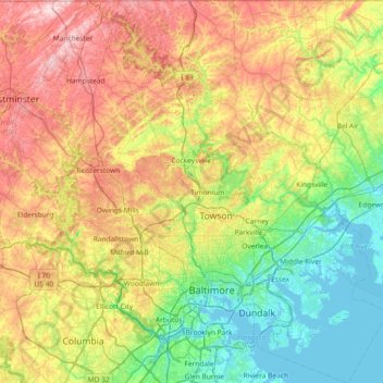
Name: Baltimore County topographic map, elevation, terrain.
Location: Baltimore County, Maryland, United States (39.15168 -76.89656 39.72120 -76.27149)
Average elevation: 123 m
Minimum elevation: -3 m
Maximum elevation: 339 m
Make a donation
Other topographic maps
Click on a map to view its topography, its elevation and its terrain.
Pasadena
United States > Maryland > Anne Arundel County
Pasadena is located at 39°6′46″N 76°33′7″W / 39.11278°N 76.55194°W / 39.11278; -76.55194 (39.112809, −76.551871) in northern Anne Arundel County. It is bordered to the north by the city of Baltimore, to the east by the tidal Patapsco River and by Riviera Beach, to the southeast by Lake…
Average elevation: 16 m