
Thank you for supporting this site ❤️
Make a donation
Make a donation
Fortuna Foothills topographic map
Click on the map to display elevation.
Thank you for supporting this site ❤️
Make a donation
Make a donation
About this map
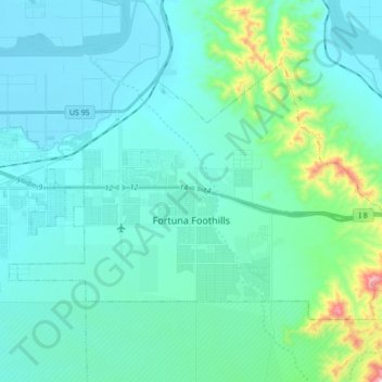
Name: Fortuna Foothills topographic map, elevation, terrain.
Location: Fortuna Foothills, Yuma County, Arizona, United States (32.61976 -114.49121 32.71813 -114.31699)
Average elevation: 133 m
Minimum elevation: 43 m
Maximum elevation: 697 m
Thank you for supporting this site ❤️
Make a donation
Make a donation
Other topographic maps
Click on a map to view its topography, its elevation and its terrain.