
Make a donation
Bolton-Est topographic map
Click on the map to display elevation.
Make a donation
About this map
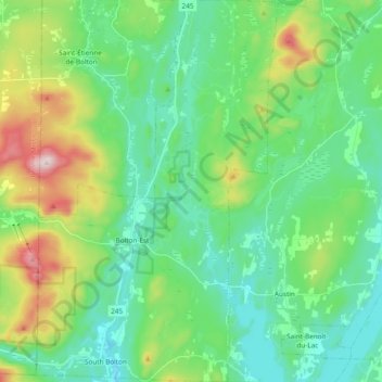
Name: Bolton-Est topographic map, elevation, terrain.
Location: Bolton-Est, Memphrémagog, Québec, J0E 1G0, Canada (45.15339 -72.40350 45.28672 -72.28331)
Average elevation: 321 m
Minimum elevation: 188 m
Maximum elevation: 702 m
Make a donation
Other topographic maps
Click on a map to view its topography, its elevation and its terrain.
Sainte Catherine de Hatley
Canada > Québec > Memphrémagog > Sainte-Catherine-de-Hatley
Average elevation: 267 m
Mont Orford
Canada > Québec > Memphrémagog > Orford
Le mont Orford, situé dans la municipalité de canton d'Orford, Québec, Canada, près de Magog, fait partie des monts Sutton et s'élève à 853 mètres d'altitude. Il fait partie du parc national du Mont-Orford. Il est aussi l'une des montagnes skiables les plus élevées du Québec.
Average elevation: 559 m
Make a donation
Make a donation
Make a donation
Make a donation
Mont Orford
Canada > Québec > Memphrémagog > Orford
Le mont Orford, montagne située dans la municipalité de canton d'Orford, Québec, Canada, près de Magog, fait partie des monts Sutton et s'élève à 853 mètres d'altitude. Il fait partie du parc national du Mont-Orford. Il est aussi l'une des montagnes skiables les plus élevées du Québec.
Average elevation: 559 m