Geolocate

Pyl Brook topographic map

Interactive map

Click on the map to display elevation.

About this map

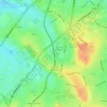
Name: Pyl Brook topographic map, elevation, terrain.

Location: Pyl Brook, Sutton, Londen, Greater London, Engeland, SM1 3HZ, VK (51.37589 -0.19716 51.38039 -0.19622)

Average elevation: 40 m

Minimum elevation: 22 m

Maximum elevation: 62 m

Other topographic maps

Click on a map to view its topography, its elevation and its terrain.

Hampstead Heath

VK > Engeland > Londen

Hampstead Heath, Hampstead, London Borough of Camden, Londen, Greater London, Engeland, VK

Average elevation: 94 m

Uxbridge

VK > Engeland > Londen > Uxbridge

Uxbridge, Londen, Greater London, Engeland, UB8 2TG, VK

Average elevation: 44 m

Barking

VK > Engeland > Londen > Barking

Barking, Londen, Greater London, Engeland, IG11 8EB, VK

Average elevation: 10 m

Surrey

VK > Engeland > Londen

Surrey, Merton Road, South Wimbledon, Merton, Londen, Greater London, Engeland, SW19 1EH, VK

Average elevation: 69 m

Lewisham

VK > Engeland > Londen > Lewisham

Lewisham, Londen, Greater London, Engeland, SE13 6BB, VK

Average elevation: 28 m

Woolwich

VK > Engeland > Londen > Woolwich

Woolwich, Londen, Greater London, Engeland, SE18 4HD, VK

Average elevation: 28 m

Waterlow Park

VK > Engeland > Londen

Waterlow Park, Tufnell Park, London Borough of Camden, Londen, Greater London, Engeland, VK

Average elevation: 77 m

Croydon

VK > Engeland > Londen > Croydon

Croydon, Londen, Greater London, Engeland, CR0 1SZ, VK

Average elevation: 70 m

Streatham

VK > Engeland > Londen > Streatham

Streatham, Londen, Greater London, Engeland, SW16 1QR, VK

Average elevation: 37 m

Tooting

VK > Engeland > Londen > Tooting

Tooting, Londen, Greater London, Engeland, SW17 0SU, VK

Average elevation: 30 m