
Make a donation
Chester County topographic map
Click on the map to display elevation.
Make a donation
Chester County
According to the U.S. Census Bureau, the county has a total area of 759 square miles (1,970 km2), of which 751 square miles (1,950 km2) is land and 8.7 square miles (23 km2) (1.1%) is water. The topography consists of rolling hills and valleys and it is part of the region known as the Piedmont.
Make a donation
About this map
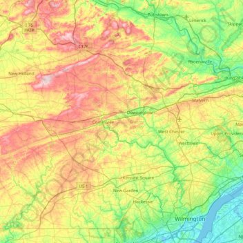
Name: Chester County topographic map, elevation, terrain.
Location: Chester County, Pennsylvania, United States (39.72149 -76.13658 40.24509 -75.36105)
Average elevation: 124 m
Minimum elevation: -5 m
Maximum elevation: 336 m
Make a donation
Other topographic maps
Click on a map to view its topography, its elevation and its terrain.
East Texas
United States > Pennsylvania > Lehigh County > Lower Macungie Township
Average elevation: 126 m
Albrightsville
United States > Pennsylvania > Carbon County > Kidder Township
Average elevation: 498 m
Donegal Lake
United States > Pennsylvania > Westmoreland County > Donegal Township
Average elevation: 493 m
Make a donation
Sturgeon
United States > Pennsylvania > Allegheny County > North Fayette Township
Average elevation: 334 m
Orefield
United States > Pennsylvania > Lehigh County > North Whitehall Township
Average elevation: 141 m
Dingmans Ferry
United States > Pennsylvania > Pike County > Delaware Township
Average elevation: 192 m
Make a donation
Middlebury Center
United States > Pennsylvania > Tioga County > Middlebury Township
Average elevation: 462 m
Woxall
United States > Pennsylvania > Montgomery County > Upper Salford Township
Average elevation: 98 m
Make a donation
Centreville
United States > Pennsylvania > Lehigh County > Lower Macungie Township
Average elevation: 144 m
Bass Lake
United States > Pennsylvania > York County > Newberry Township > Valley Green
Average elevation: 143 m
Croydon Heights
United States > Pennsylvania > Bucks County > Bristol Township > Croydon
Average elevation: 10 m
Make a donation
Fitzwatertown
United States > Pennsylvania > Montgomery County > Upper Dublin Township
Average elevation: 86 m
Starview
United States > Pennsylvania > York County > East Manchester Township
Average elevation: 155 m
North Towanda
United States > Pennsylvania > Bradford County > North Towanda Township
Average elevation: 286 m
Make a donation
Valley Forge
United States > Pennsylvania > Chester County > Schuylkill Township
Average elevation: 78 m
Make a donation
Make a donation
Freemont
United States > Pennsylvania > Chester County > West Nottingham Township
Average elevation: 115 m
Glade Mills
United States > Pennsylvania > Butler County > Middlesex Township
Average elevation: 359 m
Make a donation
Knickerbocker
United States > Pennsylvania > Chester County > Willistown Township
Average elevation: 127 m
Carlisle Springs
United States > Pennsylvania > Cumberland County > Middlesex Township
Average elevation: 182 m
Vance
United States > Pennsylvania > Washington County > South Strabane Township
Average elevation: 371 m
Sagamore Estates
United States > Pennsylvania > Pike County > Shohola Township
Average elevation: 412 m
Make a donation
Evansburg State Park
United States > Pennsylvania > Montgomery County > Worcester Township > Cedars
Average elevation: 70 m
Cross Fork
United States > Pennsylvania > Potter County > Stewardson Township
Average elevation: 467 m
Make a donation
Ithan
United States > Pennsylvania > Delaware County > Radnor Township > Saint Davids
Average elevation: 116 m
Drumore Center
United States > Pennsylvania > Lancaster County > Drumore Township
Average elevation: 175 m
Make a donation
Hanover Junction
United States > Pennsylvania > York County > North Codorus Township
Average elevation: 187 m
Stiefler Corner
United States > Pennsylvania > Bedford County > Kimmel Township
Average elevation: 520 m
Make a donation
Leather Corner Post
United States > Pennsylvania > Lehigh County > Lowhill Township
Average elevation: 178 m
Welsh Mountain Nature Preserve
United States > Pennsylvania > Lancaster County > East Earl Township
Average elevation: 294 m
East Springfield
United States > Pennsylvania > Erie County > Springfield Township
Average elevation: 229 m
Make a donation
Raven Rock Mountain
United States > Pennsylvania > Adams County > Liberty Township
Average elevation: 312 m
Strickhousers
United States > Pennsylvania > York County > North Codorus Township
Average elevation: 205 m
Make a donation
Pocono Lake
United States > Pennsylvania > Monroe County > Tobyhanna Township
Average elevation: 543 m
Intercourse
United States > Pennsylvania > Lancaster County > Leacock Township
Average elevation: 127 m
Make a donation
East Waterford
United States > Pennsylvania > Juniata County > Tuscarora Township
Average elevation: 257 m
Make a donation
Make a donation
Crooked Creek Lake
United States > Pennsylvania > Armstrong County > Bethel Township
Average elevation: 288 m
East Passyunk Community Recreation Center
United States > Pennsylvania > Philadelphia County > Philadelphia
Average elevation: 9 m
Make a donation
Make a donation
Make a donation
Coraopolis Heights
United States > Pennsylvania > Allegheny County > Findlay Township
Average elevation: 320 m
Smithville
United States > Pennsylvania > Lancaster County > Providence Township
Average elevation: 140 m
Maple Grove Park
United States > Pennsylvania > Berks County > Brecknock Township
Average elevation: 198 m
Make a donation
Mont Clare
United States > Pennsylvania > Montgomery County > Upper Providence Township
Average elevation: 56 m
Make a donation
Teepleville
United States > Pennsylvania > Crawford County > Richmond Township
Average elevation: 386 m
Central Highlands
United States > Pennsylvania > Allegheny County > Elizabeth Township
Average elevation: 327 m
Make a donation
Tyler State Park
United States > Pennsylvania > Bucks County > Northampton Township
Average elevation: 67 m
Make a donation
Make a donation