
Make a donation
Croatia topographic map
Click on the map to display elevation.
Make a donation
Croatia
The territory covers 56,594 square kilometres (21,851 square miles), consisting of 56,414 square kilometres (21,782 square miles) of land and 128 square kilometres (49 square miles) of water. It is the world's 127th largest country. Elevation ranges from the mountains of the Dinaric Alps with the highest point of the Dinara peak at 1,831 metres (6,007 feet) near the border with Bosnia and Herzegovina in the south to the shore of the Adriatic Sea which makes up its entire southwest border. Insular Croatia consists of over a thousand islands and islets varying in size, 48 of which are permanently inhabited. The largest islands are Cres and Krk, each of them having an area of around 405 square kilometres (156 square miles).
Make a donation
About this map
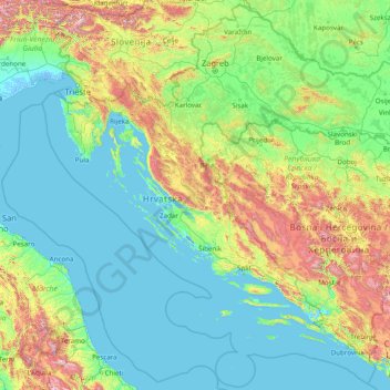
Name: Croatia topographic map, elevation, terrain.
Location: Croatia (42.17660 13.21048 46.55503 19.44727)
Average elevation: 323 m
Minimum elevation: -5 m
Maximum elevation: 2,616 m
Make a donation
Other topographic maps
Click on a map to view its topography, its elevation and its terrain.
Make a donation
Africa
Africa's topography is a complex tapestry of plateaus, mountains, valleys, and deserts. The continent is dominated by vast plateaus, with elevations averaging around 1,000 meters (3,281 feet), especially prominent in the south and east. The Ethiopian Highlands, often referred to as the "Roof of Africa," rise…
Average elevation: 462 m
Make a donation
Fort Canning Park
The hill has a long history intertwined with that of the country due to its location as the highest elevation within walking distance to the city's civic district, within the Downtown Core. It is also a popular location for exhibitions, concerts, and outdoor recreation.
Average elevation: 19 m
Make a donation
Make a donation
Make a donation
Make a donation
Make a donation
Make a donation
San Jose
The municipality is in a valley bounded on the east by the Palusong Mountain Range moving south and on the west by the Hitaasan Mountain Range. The land is generally alluvial flat and swamplands which has an elevation of less than 10 metres (33 ft) above sea level, while going south, south easterly, the…
Average elevation: 15 m
Make a donation
Kampos Marathokampou
Greece > Northern Aegean > Samos Regional Unit > Municipal Unit of Marathokabos
Average elevation: 99 m
Make a donation
Make a donation
Make a donation
Addis Ababa
Ethiopia > Addis Ababa > Arada
Addis Ababa (/ˌædɪs ˈæbəbə/ AD-iss AB-ə-bə; Amharic: አዲስ አበባ [adˈdis ˈaβəβa] , lit. 'new flower'; Oromo: Finfinnee, lit. 'fountain of hot mineral water') is the capital city of Ethiopia. With an estimated population of 2,739,551 inhabitants as of the 2007 census, it is the largest…
Average elevation: 2,517 m
Make a donation
Kotdwar
India > Uttarakhand > Kotdwara
Kotdwar lies on the western margin of the Himalayas, at an altitude of 454 m (1,490 ft) above sea level.
Average elevation: 641 m
Sinabad
Iran > West Azerbaijan Province > Urumia County > دهستان صومای جنوبی
Average elevation: 1,876 m
Make a donation
Make a donation
Aramoun
Lebanon > Mount Lebanon Governorate
Aramoun (Arabic: عرمون) is a village in the Aley District of Mount Lebanon, Lebanon, lying to the east of Khalde and 22 kilometres away from Beirut. Aramoun's altitude ranges between 250 meters to 600 meters further east. The village has a Druze and Christian community, major families are Yehia, Jawhari,…
Average elevation: 467 m
Make a donation
Corró d'Amunt
Spain > Catalonia > Vallès Oriental > les Franqueses del Vallès
Average elevation: 287 m
Make a donation
Pièce du Moulin
France > Nouvelle-Aquitaine > Charente-Maritime > Le Grand-Village-Plage
Average elevation: 4 m
Make a donation
Make a donation
Make a donation
Make a donation
Make a donation
Make a donation
Αβία
Greece > Peloponnese Region > Messenia Regional Unit > Municipal Unit of Avia
Average elevation: 45 m
Make a donation
Johannesburg
South Africa > Gauteng > City of Johannesburg Metropolitan Municipality
Johannesburg is located in the eastern plateau area of South Africa known as the Highveld, at an elevation of 1,753 metres (5,751 ft). The former Central Business District is located on the southern side of the prominent ridge called the Witwatersrand (English: White Water's Ridge) and the terrain falls to the…
Average elevation: 1,615 m
Lindridge Park
United Kingdom > England > Devon > Teignbridge > Luton > Humber
Average elevation: 125 m
Make a donation