
Thank you for supporting this site ❤️
Make a donation
Make a donation
Bolair topographic map
Click on the map to display elevation.
Thank you for supporting this site ❤️
Make a donation
Make a donation
About this map
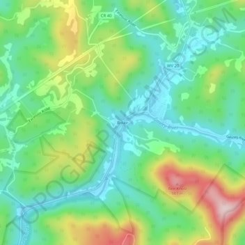
Name: Bolair topographic map, elevation, terrain.
Location: Bolair, Webster County, West Virginia, United States (38.41761 -80.46397 38.45761 -80.42397)
Average elevation: 791 m
Minimum elevation: 685 m
Maximum elevation: 1,009 m
Thank you for supporting this site ❤️
Make a donation
Make a donation
Other topographic maps
Click on a map to view its topography, its elevation and its terrain.
Addison (Webster Springs)
United States > West Virginia > Webster County
Webster Springs is located at 38°28′34″N 80°24′36″W / 38.47611°N 80.41000°W / 38.47611; -80.41000 (38.476192, -80.410025), along the Elk River. According to the United States Census Bureau, the town has a total area of 0.47 square miles (1.22 km2), of which 0.45 square miles (1.17 km2) is…
Average elevation: 602 m
Thank you for supporting this site ❤️
Make a donation
Make a donation