
Bandagiriya Tank bund2 topographic map
Interactive map
Click on the map to display elevation.
About this map
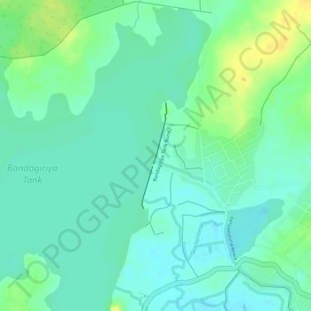
Name: Bandagiriya Tank bund2 topographic map, elevation, terrain.
Average elevation: 26 m
Minimum elevation: 16 m
Maximum elevation: 41 m
Other topographic maps
Click on a map to view its topography, its elevation and its terrain.
Hiyare
Hiyare, Galle District, Southern Province, 80090, Sri Lanka
Average elevation: 41 m
Weerawila
Weerawila, Hambantota District, Southern Province, 82632, Sri Lanka
Average elevation: 30 m
Yodha Kandiya
Yodha Kandiya, Hambantota District, Southern Province, 82600, Sri Lanka
Average elevation: 17 m
Ambalantota
Ambalantota, Hambantota District, Southern Province, 82100, Sri Lanka
Average elevation: 7 m
Nonagama
Nonagama, Hambantota District, Southern Province, 82100, Sri Lanka
Average elevation: 11 m
Baddegama
Baddegama, Galle District, Southern Province, 80333, Sri Lanka
Average elevation: 11 m
Matara
Matara, Matara District, Southern Province, 81000, Sri Lanka
Average elevation: 21 m
Hambantota
Sri Lanka > Southern Province > Hambantota
Hambantota, Hambantota District, Southern Province, Sri Lanka
Average elevation: 12 m