
Make a donation
Aldeadávila de la Ribera topographic map
Click on the map to display elevation.
Make a donation
Aldeadávila de la Ribera
Aldeadávila de la Ribera has a predominantly gentle, hilly relief, typical of the Zamoran-Salamancan peneplain of the Northern Plateau, which contrasts with the deep river beds of the River Duero and its tributaries. Its average altitude ranges between 2395 ft and 2198 ft, with the highest point being the Pico de la Cabeza (2545 ft) and the lowest point being the bank of the Duero River at the base of the Aldeadávila Dam (623 ft).
Make a donation
About this map
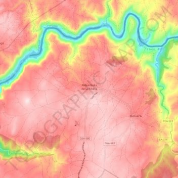
Name: Aldeadávila de la Ribera topographic map, elevation, terrain.
Location: Aldeadávila de la Ribera, Salamanca, Castile and León, Spain (41.17968 -6.69947 41.25524 -6.58052)
Average elevation: 619 m
Minimum elevation: 324 m
Maximum elevation: 765 m
Make a donation
Other topographic maps
Click on a map to view its topography, its elevation and its terrain.
Make a donation
Make a donation
Make a donation
Make a donation
Sierra de Guadarrama
The range runs southwest–northeast, extending from the province of Ávila in the southwest, through the Community of Madrid, to the province of Segovia in the northeast. The range measures approximately 80 kilometres (50 mi) in length. Its highest peak is Peñalara, 2,428 metres (7,966 ft) in elevation.
Average elevation: 1,153 m
Make a donation
Make a donation
Make a donation
Make a donation
Make a donation
Make a donation
Make a donation
Make a donation
Yacimiento arqueológico La Edrada
Spain > Castile and León > El Bierzo > Cacabelos
Average elevation: 493 m
Make a donation
Make a donation
Make a donation
Make a donation
Make a donation
Make a donation
Make a donation
Make a donation
Make a donation
Poblado del Salto de Aldeadávila
Spain > Castile and León > Aldeadávila de la Ribera
Average elevation: 535 m
Make a donation
Make a donation
Make a donation
Make a donation