
Île Stewart topographic map
Interactive map
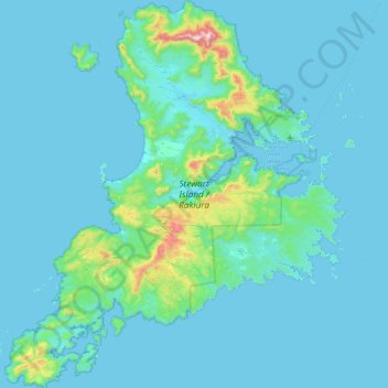
Click on the map to display elevation.
About this map
Name: Île Stewart topographic map, elevation, terrain.
Location: Île Stewart, Southland, Nouvelle-Zélande (-47.29000 167.44721 -46.68343 168.22927)
Average elevation: 63 m
Minimum elevation: -2 m
Maximum elevation: 967 m
L'île a une superficie de 1 746 km². Le nord de l'île est façonné par la vallée marécageuse de la Freshwater prenant sa source près de la côte nord-ouest et s'écoulant vers le sud-est à travers la large échancrure de l'anse de Paterson. Le point culminant de l'île est le mont Anglem, près de la côte nord, à une altitude de 979 m. Il fait partie d'une couronne de crêtes encerclant la vallée de la Freshwater.
Other topographic maps
Click on a map to view its topography, its elevation and its terrain.
Aiguille Rouge
Nouvelle-Zélande > Southland > Southland District > Fiordland Community
Aiguille Rouge, Fiordland Community, Southland District, Southland, Nouvelle-Zélande
Average elevation: 1,058 m
Milford Sound / Piopiotahi
Nouvelle-Zélande > Southland > Southland District > Fiordland Community
Milford Sound / Piopiotahi, Fiordland Community, Southland District, Southland, Nouvelle-Zélande
Average elevation: 655 m
Te Anau
Nouvelle-Zélande > Southland > Southland District > Fiordland Community
Te Anau, Fiordland Community, Southland District, Southland, 9600, Nouvelle-Zélande
Average elevation: 249 m