
Province of Lambayeque topographic map
Interactive map
Click on the map to display elevation.
About this map
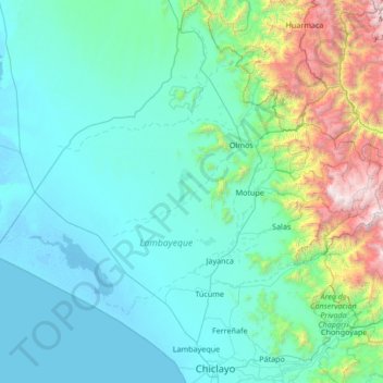
Name: Province of Lambayeque topographic map, elevation, terrain.
Location: Province of Lambayeque, Lambayeque, Peru (-6.82134 -80.62713 -5.48039 -79.40181)
Average elevation: 510 m
Minimum elevation: -6 m
Maximum elevation: 4,019 m
Other topographic maps
Click on a map to view its topography, its elevation and its terrain.
Morrope
Peru > Lambayeque > Mórrope
Morrope, Mórrope, Province of Lambayeque, Lambayeque, Peru
Average elevation: 19 m
Lambayeque
Peru > Lambayeque > Lambayeque
Lambayeque, Province of Lambayeque, Lambayeque, Peru
Average elevation: 24 m
Puerto Etén
Peru > Lambayeque > Etén Puerto > Puerto Etén
Puerto Etén, Etén Puerto, Province of Chiclayo, Lambayeque, Peru
Average elevation: 11 m
Chiclayo
Peru > Lambayeque > Chiclayo
Chiclayo, Province of Chiclayo, Lambayeque, 5174, Peru
Average elevation: 39 m
Incahuasi
Peru > Lambayeque > Incahuasi
Incahuasi, Province of Ferreñafe, Lambayeque, Peru
Average elevation: 2,663 m
Hacienda Janque
Peru > Lambayeque > Incahuasi > Hacienda Janque
Hacienda Janque, Incahuasi, Province of Ferreñafe, Lambayeque, Peru
Average elevation: 2,247 m
Province of Ferreñafe
Province of Ferreñafe, Lambayeque, Peru
Average elevation: 1,083 m
Province of Lambayeque
Peru > Lambayeque > Jayanca
Province of Lambayeque, Jayanca, Lambayeque, Peru
Average elevation: 77 m
Province of Ferreñafe
Peru > Lambayeque > Pítipo
Province of Ferreñafe, Pítipo, Ferreñafe, Lambayeque, Peru
Average elevation: 612 m