
屏東縣 topographic map
Interactive map
Click on the map to display elevation.
About this map
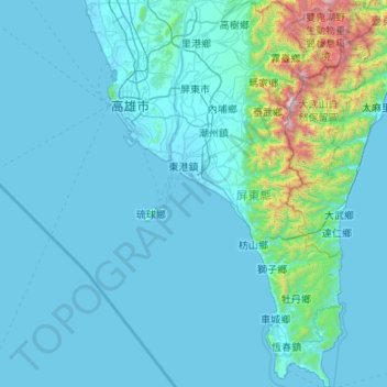
Name: 屏東縣 topographic map, elevation, terrain.
Location: 屏東縣, 臺灣 (21.89686 120.35290 22.88515 120.90419)
Average elevation: 199 m
Minimum elevation: -3 m
Maximum elevation: 2,963 m
屏東縣的西部為地形較平坦的屏東平原,農漁業發達,是人口集中的菁華區。平原區以東則為地勢較高的丘陵與山地,屬中央山脈南段,其中北大武山海拔逾三千公尺,是山脈南段、也是全縣的最高峰,也是台灣原住民排灣族群的聖山。山區的地勢往南陡降,並延伸到恆春半島。
Other topographic maps
Click on a map to view its topography, its elevation and its terrain.