
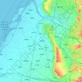
彰化縣 topographic map
Interactive map
Click on the map to display elevation.
About this map
Name: 彰化縣 topographic map, elevation, terrain.
Location: 彰化縣, 臺灣 (23.78561 120.22036 24.20718 120.68395)
Average elevation: 77 m
Minimum elevation: -2 m
Maximum elevation: 615 m
彰化縣(臺灣話:Tsiong-huà-kuān;客家话:Chông-fa-yen)為中華民國臺灣的縣,有「臺灣米倉」之稱,位於臺灣本島中部,東邊以八卦山脈與南投縣接壤,西邊濱臨臺灣海峽,南邊以濁水溪與雲林縣為界,北邊以烏溪與臺中市為界。福建巡撫王紹蘭之彰化縣碑記中記載:「實獲眾心、保域、保民,彰聖天子丕昌海隅之化歟」,即「顯彰皇化」之佳稱。後雍正帝賜名稱彰化,為「建學立師,以彰雅化」之意,便以彰化為縣名。彰化縣為臺灣人口排行第一位的縣級行政區,也是人口唯一突破百萬的縣,為臺灣第一大縣。彰化縣地形上以平原為主,北邊屬於彰化平原,南邊則是濁水溪沖積平原,該縣常與臺中市及南投縣合稱中彰投地區,或與雲林縣、嘉義市、嘉義縣等三縣市合稱彰雲嘉地區。
Other topographic maps
Click on a map to view its topography, its elevation and its terrain.