
Make a donation
Tabuk Province topographic map
Click on the map to display elevation.
Make a donation
About this map
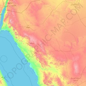
Name: Tabuk Province topographic map, elevation, terrain.
Location: Tabuk Province, Saudi Arabia (24.56184 34.49441 29.97559 39.94176)
Average elevation: 695 m
Minimum elevation: 0 m
Maximum elevation: 2,482 m
Make a donation
Other topographic maps
Click on a map to view its topography, its elevation and its terrain.
Make a donation
Ar Rub` al Khali
Saudi Arabia > Eastern Province > Al Ahsa Governorate
The desert is 1,000 kilometres (620 miles) long, and 500 kilometres (310 miles) wide. Its surface elevation varies from 800 metres (2,600 ft) in the southwest to around sea level in the northeast. The terrain is covered with sand dunes with heights up to 250 metres (820 ft), interspersed with gravel and gypsum…
Average elevation: 183 m
Make a donation
Khubayb ar Rim
Saudi Arabia > Riyadh Region > Al Muzahimiyah > Khubayb ar Rim
Average elevation: 704 m
Neom
On 3 March 2022, the Trojena project was launched, which will potentially be the first major outdoor skiing destination in the Arabian Peninsula. The project's site is about 50 kilometres (31 mi) from the Gulf of Aqaba coast in the Sarat Mountains, with elevations ranging from 1,500–2,600 metres…
Average elevation: 52 m