
Make a donation
Hamedan topographic map
Click on the map to display elevation.
Make a donation
About this map
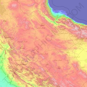
Name: Hamedan topographic map, elevation, terrain.
Location: Hamedan, Iran (32.83231 45.96651 38.03231 51.16651)
Average elevation: 1,465 m
Minimum elevation: -31 m
Maximum elevation: 4,553 m
Make a donation
Other topographic maps
Click on a map to view its topography, its elevation and its terrain.
Tehran
Iran > Tehran Province > Tehran County
As the city has a large area, with significant differences in elevation among various districts, the weather is often cooler in the hilly north than in the flat southern part of Tehran. For instance, the 17.3 km (10.7 mi) Valiasr Street runs from Tehran's railway station at 1,117 m (3,665 ft) elevation above…
Average elevation: 1,539 m
Tehran
Iran > Tehran Province > Tehran County
Tehran, located in the northern part of Iran, is set against the backdrop of the Alborz mountain range, which towers prominently to the north. The city itself is perched at approximately 3,750 feet (1,143 meters) above sea level, providing a striking contrast between its urban landscape and the rugged terrain…
Average elevation: 1,539 m
Bandar Abbas
Iran > Hormozgan Province > Bandar-e-Abbas County
Bandar Abbas is situated on flat ground with an average altitude of 9 metres (30 ft) above sea level. The nearest elevated areas are Mt. Geno, 17 kilometres (11 mi) to the north, and Mt. Pooladi, 16 kilometres (9.9 mi) to the northwest of the city. The closest river to Bandar Abbas is the River Shoor, which…
Average elevation: 27 m
Make a donation
Make a donation
Make a donation
Kashan
Iran > Isfahan Province > Kashan County
Kashan has a hot desert climate, with (BWh) designation in Köppen climate classification and (BW) in Trewartha climate classification, with cold winters (although warmer than other Iranian cities) and very hot and dry summers. Kashan is significantly warmer than other cities in the Iranian Plateau due to its…
Average elevation: 964 m
Shiraz
Iran > Fars Province > Shiraz County
Shiraz's climate has distinct seasons, and is overall classed as a cold semi-arid climate (Köppen climate classification BSk), though it is only a little short of a hot semi-arid climate (BSh) or a hot-summer Mediterranean climate (Köppen climate classification Csa). Summers are hot, with a July average high…
Average elevation: 1,785 m
Bijar
Iran > Kurdistan Province > Bijar County
With an elevation of 1,940 metres, Bijar has been called the Roof of Iran.
Average elevation: 2,004 m
Isfahan
Iran > Isfahan Province > Isfahan County
Situated at 1,590 metres (5,217 ft) above sea level on the eastern side of the Zagros Mountains, Isfahan has a cold desert climate (Köppen BWk). No geological obstacles exist within 90 kilometres (56 miles) north of the city, allowing cool winds to blow from this direction. Despite its altitude, Isfahan…
Average elevation: 1,607 m
Make a donation
Mazandaran Province
Mazandaran Province naturally comes under the influence of the geographical latitude, the Alborz mountain range, elevation from sea level, distance from the sea, and the southern barren areas of Turkmenistan, local and regional air currents, and versatile vegetation cover. These conditions result in the…
Average elevation: 863 m
Make a donation
Tehran
Iran > Tehran Province > Tehran County
Northern Tehran is at the foot of Alborz, starting at an elevation of 1,800 meters (5,900 ft), with many houses and streets on steep slopes and hills. There is a stretch of hills in the middle of the city (which historically divided Tehran and Shemiran) with its highest point at 1,500 metres (4,900 ft).…
Average elevation: 1,539 m
Shiraz
Iran > Fars Province > Shiraz County
Shiraz's climate has distinct seasons, and is overall classed as a cold semi-arid climate (Köppen climate classification BSk), though it is only a little short of a hot semi-arid climate (BSh) or a hot-summer Mediterranean climate (Köppen climate classification Csa). Summers are hot, with a July average high…
Average elevation: 1,785 m
Make a donation
Make a donation
Gorgan
Iran > Golestan Province > Gorgan County
Gorgan has a subtropical mediterranean climate (Köppen: Csa, Trewartha: Cs), with hot, humid summers and cool, wet winters. In general, Golestan has a moderate and humid climate known as "the moderate Caspian climate". The effective factors behind such a climate are Alborz mountain range, the direction of the…
Average elevation: 187 m
Lahijan City
Iran > Gilan Province > Lahijan County
Lahijan is located west of Langarud and east of Astaneh-ye Ashrafiyeh at an altitude of 94 meters above sea level. It is the third largest city in the province after Rasht and Bandar-e Anzali.
Average elevation: 17 m
Make a donation
Karaj
Iran > Alborz Province > Karaj County
One of the international ski resorts of Iran The, Dizin ski resort, is located a few kilometers north-east of the city, in the Alborz. In Dizin, along with skiing facilities, there are tennis courtyards, a slope for skiing on turf, some altitudes for mountain climbing and walking as well as riding and some…
Average elevation: 1,505 m
Make a donation
Tehran
Iran > Tehran Province > Tehran County
As the city has a large area, with significant differences in elevation among various districts, the weather is often cooler in the hilly north than in the flat southern part of Tehran. For instance, the 17.3 km (10.7 mi) Valiasr Street runs from Tehran's railway station at 1,117 m (3,665 ft) elevation above…
Average elevation: 1,539 m
Make a donation
Tabriz
Iran > East Azerbaijan Province > Tabriz County
Tabriz (Persian: تبریز [tæbˈɾiːz] (listen); Azerbaijani: تبریز) is a city in northwestern Iran, serving as the capital of East Azerbaijan Province. It is the sixth-most-populous city in Iran. In the Quru River valley in Iran's historic Azerbaijan region between long ridges of volcanic cones in…
Average elevation: 1,538 m
Make a donation
Qazvin
Iran > Qazvin Province > Qazvin County
Located in 150 km (93 mi) northwest of Tehran, in the Qazvin Province, it is at an altitude of about 1,800 m (5,900 ft) above sea level. Due to its position at the south of the rugged Alborz range called KTS Atabakiyam, its climate is cold but dry.
Average elevation: 1,324 m
Gorgan
Iran > Golestan Province > Gorgan County
Gorgan has a subtropical mediterranean climate (Köppen: Csa, Trewartha: Cs), with hot, humid summers and cool, wet winters. In general, Golestan has a moderate and humid climate known as "the moderate Caspian climate". The effective factors behind such a climate are Alborz mountain range, the direction of the…
Average elevation: 182 m
Make a donation
Make a donation
Ilam Province
Contrary to the north, the south and southwestern part of the province is covered with low-lying plains with elevation varying between 50 and 300 m (160 and 980 ft) above sea level. Despite receiving little precipitation, large areas of these low lands, notably Dehloran, Musian and Dasht Abbas, are cultivated…
Average elevation: 630 m
Make a donation
Ardabil
Iran > Ardabil Province > Ardabil city
Ardabil is located on the Baliqly Chay River, about 70 km (43 mi) from the Caspian Sea(Khazar), and 210 km (130 mi) from the city of Tabriz. It has an average altitude of 1,263 metres (4,144 ft) and total area of 18.011 km2 (6.954 sq mi). Neighboring on the Caspian Sea. It has been of great political and…
Average elevation: 1,358 m
Make a donation
Tehran
Iran > Tehran Province > Tehran County
As the city has a large area, with significant differences in elevation among various districts, the weather is often cooler in the hilly north than in the flat southern part of Tehran. For instance, the 17.3 km (10.7 mi) Valiasr Street runs from Tehran's railway station at 1,117 m (3,665 ft) elevation above…
Average elevation: 1,539 m
Bandar Abbas
Iran > Hormozgan Province > Bandar-e-Abbas County
Bandar Abbas is situated on flat ground with an average altitude of 9 metres (30 ft) above sea level. The nearest elevated areas are Mt. Geno, 17 kilometres (11 mi) to the north, and Mt. Pooladi, 16 kilometres (9.9 mi) to the northwest of the city. The closest river to Bandar Abbas is the River Shoor, which…
Average elevation: 27 m
Jiroft
Iran > Kerman Province > Jiroft County
Jiroft is in a vast plain, Halil River, on the southern outskirts of the Jebal Barez mountain chain, surrounded by two rivers. The mean elevation of the city is about 650 metres (2,130 ft) above sea level. The weather of the city is sweltering in summer – it is one of the hottest places in Iran – but…
Average elevation: 692 m
Make a donation
Kerman Province
The altitudes and heights of the province are the continuation of the central mountain ranges of Iran. They extend from the volcanic folds beginning in Azerbaijan and, by branching out in the central plateau of Iran, terminate in Baluchestan. These mountain ranges have brought about vast plains in the…
Average elevation: 1,150 m
Jiroft
Iran > Kerman Province > Jiroft County
Jiroft lies in an alluvial plain of the Halil River, on the southern outskirts of the Jebal Barez mountain chain. It sits in a tectonically active basin, at the northern end of the Bandar Abbas-Jiroft fault zone, with both structural and anthropogenic subsidence occurring. Two intermittent streams join the…
Average elevation: 695 m
Make a donation
Karaj County
One of the international ski resorts of Iran The, Dizin ski resort, is located a few kilometers north-east of the city, in the Alborz. In Dizin, along with skiing facilities, there are tennis courtyards, a slope for skiing on turf, some altitudes for mountain climbing and walking as well as riding and some…
Average elevation: 1,965 m
Shiraz
Iran > Fars Province > Shiraz County
Shiraz's climate has distinct seasons, and is overall classed as a cold semi-arid climate (Köppen climate classification BSk), though it is only a little short of a hot semi-arid climate . Summers are hot, with a July average high of 37.9 °C (100.2 °F). Winters are cool, with average low temperatures below…
Average elevation: 1,785 m
Amol
Iran > Mazandaran Province > Amol County
Amol is located on the banks of the Haraz River (26 25'N 52 21'E) at an altitude of 76 m above the sea. It is about 18 km from the Caspian Sea and about 10 km from the northern Alborz mountains. It is 180 km from the Iranian capital, Tehran, with a picturesque drive through Haraz Road. Sari, the capital of…
Average elevation: 90 m
Make a donation
Make a donation
Tehran
Iran > Tehran Province > Tehran County
Northern Tehran is at the foot of Alborz, starting at an elevation of 1,800 meters (5,900 ft), with many houses and streets on steep slopes and hills. There is a stretch of hills in the middle of the city (which historically divided Tehran and Shemiran) with its highest point at 1,500 metres (4,900 ft).…
Average elevation: 1,539 m
Make a donation
Make a donation
Hamedan
Iran > Hamadan Province > Hamedan County
Hamadan spot (light blue in center) in Hamadan province topography map
Average elevation: 1,880 m
Isfahan
Iran > Isfahan Province > Isfahan County
Situated at 1,590 metres (5,217 ft) above sea level on the eastern side of the Zagros Mountains, Isfahan has a cold desert climate (Köppen BWk). No geological obstacles exist within 90 kilometres (56 miles) north of the city, allowing cool winds to blow from this direction. Despite its altitude, Isfahan…
Average elevation: 1,607 m
Make a donation
دریاچه سد البرز (لفور)
Iran > Mazandaran Province > Babol County > دهستان لفور > اسبوکلا
Average elevation: 386 m
Isfahan
Iran > Isfahan Province > Isfahan County
Isfahan has a cold desert climate (Köppen: BWk), characterized by low annual precipitation, clear skies, strong sunlight, and large temperature fluctuations between day and night. The city, situated at an elevation of approximately 1,570 meters above sea level, experiences hot, dry summers and cool to cold…
Average elevation: 1,607 m
Make a donation
Pardisan Park
Iran > Sistan and Baluchestan Province > Zahedan County > Zahedan
Average elevation: 1,400 m
Make a donation
Varzaneh
Iran > Isfahan Province > Golpayegan County > Golshahr
Golpayegan (Persian: گلپایگان) is a city in the Central District of Golpayegan County, Isfahan, Iran, serving as capital of both the county and the district. The city is 186 kilometres (116 mi) northwest of Isfahan and 102 kilometres (63 mi) southeast of Arak, at an altitude of 1,830 m. Its temperature…
Average elevation: 1,780 m
Bandar Abbas
Iran > Hormozgan Province > Bandar-e-Abbas County
Bandar Abbas is situated on flat ground with an average altitude of 9 metres (30 ft) above sea level. The nearest elevated areas are Mt. Geno, 17 kilometres (11 mi) to the north, and Mt. Pooladi, 16 kilometres (9.9 mi) to the northwest of the city. The closest river to Bandar Abbas is the River Shoor, which…
Average elevation: 27 m
Make a donation