
Make a donation
Municipio de Tijuana topographic map
Click on the map to display elevation.
Make a donation
About this map
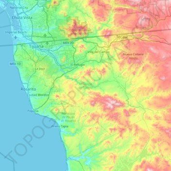
Name: Municipio de Tijuana topographic map, elevation, terrain.
Location: Municipio de Tijuana, Baja California, Mexico (32.18522 -117.30054 32.57107 -116.52399)
Average elevation: 369 m
Minimum elevation: -2 m
Maximum elevation: 1,330 m
Make a donation
Other topographic maps
Click on a map to view its topography, its elevation and its terrain.
Tijuana
Mexico > Baja California > Municipio de Tijuana
Housing development in the Tijuana Hills has led to eradication of many seasonal mountain streams. This lack of natural drainage makes places within the city vulnerable to landslides during the rainy season. The varied terrain of Tijuana gives the city elevation extremes that range from sea level to 790 meters…
Average elevation: 141 m
Rosarito
Mexico > Baja California > Municipio de Playas de Rosarito
Playas de Rosarito lies on the coast of the Pacific Ocean on the North Baja California Peninsula. The city is positioned between the foothills of the Peninsular Ranges and the ocean. It maintains a relatively uniform topography and displays few variances in terrain.
Average elevation: 103 m
Make a donation
Tijuana
Mexico > Baja California > Municipio de Tijuana
Housing development in the Tijuana Hills has led to eradication of many seasonal mountain streams. This lack of natural drainage makes places within the city vulnerable to landslides during the rainy season. The varied terrain of Tijuana gives the city elevation extremes that range from sea level to 790 meters…
Average elevation: 141 m
Make a donation
Los Algodones
Mexico > Baja California > Municipio de Mexicali
The town is at an elevation of 110 feet/33.5 m above mean sea level.
Average elevation: 51 m
Make a donation
Playas de la Vicente Guerrero
Mexico > Baja California > Municipio de San Quintín > Santa Fe
Average elevation: 27 m
Parque Nacional Sierra de San Pedro Mártir
Mexico > Baja California > Municipio de Ensenada
Sierra de San Pedro Mártir National Park was officially created by decree on April 26, 1947, in which 72,909 hectares were set aside and declared protected by the Mexican Federal government. The National Astronomical Observatory is located at an elevation of 2,830 m (9,280 ft). The observatory was built in…
Average elevation: 1,463 m
Reserva Natural UABC Otay
Mexico > Baja California > Municipio de Tijuana > Tijuana
Average elevation: 137 m
Make a donation
Make a donation
Make a donation
Parque Ejido Monterrey No. 2
Mexico > Baja California > Municipio de Mexicali > Monterrey (Batáquez)
Average elevation: 19 m
Make a donation
Laguna de Santo Tomás
Mexico > Baja California > Municipio de Ensenada > La Bocana
Average elevation: 40 m
Ejido El Porvenir
Mexico > Baja California > Municipio de Ensenada
The valley slopes gently from northeast to southwest with an average elevation of 344 metres (1,129 ft) above sea level. The margins of the plain are composed of alluvial fans and colluvium of reddish soil from the surrounding hillsides. Chaparral grows along the rocky slopes and live oak trees can be found in…
Average elevation: 317 m
Make a donation
Tijuana
Mexico > Baja California > Municipio de Tijuana
Housing development in the Tijuana Hills has led to eradication of many seasonal mountain streams. This lack of natural drainage makes places within the city vulnerable to landslides during the rainy season. The varied terrain of Tijuana gives the city elevation extremes that range from sea level to 790 meters…
Average elevation: 141 m
Francisco Zarco (Valle de Guadalupe)
Mexico > Baja California > Municipio de Ensenada
Average elevation: 384 m
Make a donation
Tijuana
Mexico > Baja California > Municipio de Tijuana
Housing development in the Tijuana Hills has led to eradication of many seasonal mountain streams. This lack of natural drainage makes places within the city vulnerable to landslides during the rainy season. The varied terrain of Tijuana gives the city elevation extremes that range from sea level to 790 meters…
Average elevation: 141 m
Make a donation
Los Volcanes
Mexico > Baja California > Municipio de Playas de Rosarito > Ciudad Morelos
Average elevation: 147 m
Tecate
Mexico > Baja California > Municipio de Tecate
Tecate's altitude of approximately 540 m (1,770 ft) above sea level and its proximity to the ocean contribute to the temperate climate. It rains enough in the area (almost 360 mm [14 in] per year) for a thick ground cover of shrubs and scattered trees to grow.
Average elevation: 595 m
Make a donation