
Make a donation
River Trent topographic map
Click on the map to display elevation.
Make a donation
River Trent
A distinctive feature of the catchment is the marked variation in the topography and character of the landscape, which varies from the upland moorland headwaters of the Dark Peak, where the highest point of the catchment is the Kinder Scout plateau at 634 metres (2,080 ft); through to the intensively farmed and drained flat fenland areas that exist alongside the lower tidal reaches, where ground levels can equal sea level. These lower reaches are protected from tidal flooding by a series of floodbanks and defences.[31][32][33]
Make a donation
About this map
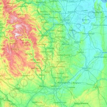
Name: River Trent topographic map, elevation, terrain.
Location: River Trent, England, DE15 9AW, United Kingdom (52.72994 -2.20584 53.70154 -0.68558)
Average elevation: 121 m
Minimum elevation: -1 m
Maximum elevation: 633 m
Make a donation
Other topographic maps
Click on a map to view its topography, its elevation and its terrain.
Make a donation
Wilstone Reservoir
United Kingdom > England > Hertfordshire > Dacorum > Wilstone
Average elevation: 110 m
Make a donation
Gibsmere
United Kingdom > England > Nottinghamshire > Newark and Sherwood > Bleasby
Average elevation: 30 m
Make a donation
Make a donation
Bury Hey Wood
United Kingdom > England > Lancashire > West Lancashire > Appley Bridge > Robin Hood
Average elevation: 106 m
Make a donation
Make a donation
Reigate
United Kingdom > England > Surrey > Reigate and Banstead
Reigate is in central Surrey, around 19 mi (30 km) south of central London and 9 mi (14 km) north of Gatwick Airport. The town is in the Vale of Holmesdale, below the North Downs escarpment. The average elevation in the centre is 80 m (260 ft) above ordnance datum (OD) and the area is drained by the Wallace…
Average elevation: 100 m
Make a donation
Make a donation
Fleet Hargate
United Kingdom > England > Lincolnshire > South Holland > Fleet Hargate
Average elevation: 3 m