
Make a donation
Sysendammen topographic map
Click on the map to display elevation.
Make a donation
About this map
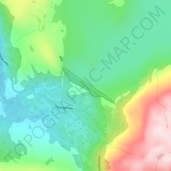
Name: Sysendammen topographic map, elevation, terrain.
Location: Sysendammen, Eidfjord, Vestland, Norway (60.40142 7.37584 60.40729 7.39297)
Average elevation: 933 m
Minimum elevation: 810 m
Maximum elevation: 1,181 m
Make a donation
Other topographic maps
Click on a map to view its topography, its elevation and its terrain.
Troll tongue
The hike from the parking area to Trolltunga and back again is a 27-kilometre (17 mi) round-trip distance with a 1,100-metre (3,600 ft) gain in elevation, and it takes approximately 10–12 hours, including breaks.
Average elevation: 1,091 m
Make a donation
Make a donation
Make a donation
Make a donation
Make a donation
Make a donation
Make a donation
Make a donation
Hornelen
The horizontal distance from the summit to the sea is approximately 500 metres (1,600 ft). Approximately 1 kilometre (0.62 mi) to the west of the cliffside is the highest point on the island Bremangerlandet, called Svartevassegga which has an elevation of 889 metres (2,917 ft). The rock in Hornelen consists of…
Average elevation: 282 m
Make a donation
Make a donation
Troll tongue
The hike from the parking area to Trolltunga and back again is a 27-kilometre (17 mi) round-trip distance with a 1,100-metre (3,600 ft) gain in elevation, and it takes approximately 10–12 hours, including breaks.
Average elevation: 1,091 m
Make a donation
Make a donation
Make a donation
Make a donation
Make a donation
Make a donation
Make a donation
Make a donation
Make a donation
Make a donation
Make a donation
Make a donation