
Make a donation
Tucumcari topographic map
Click on the map to display elevation.
Make a donation
About this map
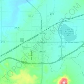
Name: Tucumcari topographic map, elevation, terrain.
Location: Tucumcari, New Mexico, 88401, United States (35.13194 -103.76504 35.21194 -103.68504)
Average elevation: 1,252 m
Minimum elevation: 1,202 m
Maximum elevation: 1,513 m
Make a donation
Other topographic maps
Click on a map to view its topography, its elevation and its terrain.
Bandelier National Monument
United States > New Mexico > Sandoval County
The monument is 50 square miles (130 km2) of the Pajarito Plateau, on the slopes of the Jemez volcanic field in the Jemez Mountains. Over 70% of the monument is wilderness, with over one mile of elevation change, from about 5,000 feet (1,500 m) along the Rio Grande to over 10,000 feet (3,000 m) at the peak of…
Average elevation: 2,130 m
Make a donation
Capulin Volcano National Monument
United States > New Mexico > Union County
Capulin Volcano National Monument is a well-preserved, relatively young (55,000 to 62,000 years old), symmetrical cinder cone. It rises steeply from the surrounding grassland plains to an elevation of 8,182 feet above sea level. The irregular rim of the crater is about a mile in circumference and the crater…
Average elevation: 2,195 m
Make a donation
Make a donation
Lake Farmington Recreation Area
United States > New Mexico > San Juan County > Farmington
Average elevation: 1,723 m
Taos Ski Valley
United States > New Mexico > Taos County
Taos Ski Valley is a village and alpine ski resort in the southwestern United States, located in Taos County, New Mexico. The population was 69 at the 2010 census. Until March 19, 2008, it was one of four ski resorts in America to prohibit snowboarding. The Kachina lift, constructed in 2014, serves one of the…
Average elevation: 3,307 m
Make a donation
Thoreau
United States > New Mexico > McKinley County
Thoreau is located at an altitude of approximately 2,200 meters (7,200 feet) above sea level, and 8 kilometers (5.0 mi) east of the continental divide. Thoreau is located in a broad valley beneath a large escarpment of Entrada sandstone, which marks the southern boundary of the Colorado Plateau to the north.…
Average elevation: 2,253 m
Navajo Lake State Park
United States > New Mexico > San Juan County > Navajo Dam
Average elevation: 1,966 m
Make a donation
Make a donation
Bayard
United States > New Mexico > Grant County
Bayard is located in the southern foothills of the Pinos Altos Range and Mogollon Mountains in the southwestern portion of New Mexico and situated east of the Continental Divide at an elevation of approximately 5,800 feet (1,800 m). Gila National Forest lies north from here. A semi-arid desert of predominantly…
Average elevation: 1,816 m
Make a donation
Make a donation
El Malpais National Conservation Area
United States > New Mexico > Cibola County
Average elevation: 2,256 m
Make a donation
White Sands National Park
United States > New Mexico > Otero County
The first US Army exploration of south-central New Mexico was led by a party of topographical engineering officers in 1849. They passed west of the San Andres Mountains and Organ Mountains. A lieutenant was dispatched east across the basin with a scouting party to map a potential military wagon route to the…
Average elevation: 1,214 m
Make a donation
Make a donation
Kasha-Katuwe Tent Rocks National Monument
United States > New Mexico > Sandoval County
Average elevation: 1,852 m
Make a donation
Ohkay Owingeh
United States > New Mexico > Rio Arriba County
Its elevation is 5,663 feet (1,726 m) and it is located at 36°03′12″N 106°04′08″W / 36.05333°N 106.06889°W / 36.05333; -106.06889. One of its boundaries is contiguous with Española, about 25 miles (40 km) north of Santa Fe.
Average elevation: 1,726 m
Make a donation
Make a donation
Columbus
United States > New Mexico > Luna County
The climate is a cold semi-arid (Köppen: BSk) like much of New Mexico's lower elevations outside El Paso–Juárez.
Average elevation: 1,238 m
Organ Mountains-Desert Peaks National Monument
United States > New Mexico > Doña Ana County
Average elevation: 1,335 m
Pecos National Historic Park
United States > New Mexico > San Miguel County > Pecos
Average elevation: 2,239 m
Make a donation
Ruidoso Downs
United States > New Mexico > Lincoln County > Ruidoso Downs
Ruidoso Downs is located in southern Lincoln County at 33°19′54″N 105°35′46″W / 33.33167°N 105.59611°W / 33.33167; -105.59611 (33.331690, -105.596079). It is bordered to the west by Ruidoso. Elevation is 6,420 feet (1,960 m).
Average elevation: 2,091 m
Make a donation
Aztec
United States > New Mexico > Aztec
Yet another area managed by the BLM, this area was formed about the same time as the Bisti and Ah-Shi-Sle-Pah. This region offers a uniquely different scale of landscape. Hoodoo in this region are massive and the terrain much greater in elevation differences, thereby exposing a greater geological time frame…
Average elevation: 1,776 m
Los Alamos
United States > New Mexico > Los Alamos County > Los Alamos
Los Alamos is located in northern New Mexico between the Rio Grande and the eastern rim of the Valles Caldera on the Pajarito Plateau, approximately 35 mi (56 km) to the northwest of Santa Fe. The elevation at the post office is 7,320 feet (2,230 m) and total land area is 11.14 square miles (28.9 km2).
Average elevation: 2,196 m
Make a donation
Joe M. Lucero Hillside
United States > New Mexico > Bernalillo County > Albuquerque
Average elevation: 1,637 m
Folsom
United States > New Mexico > Union County
Folsom is situated in a wide valley near the headwaters of the Cimarron River, locally known as the Dry Cimarron, as it runs underground during part of its course through eastern New Mexico. The village is ringed by buttes, mesas, and old volcanic cones and lava flows. Most of the valley is rich grassland,…
Average elevation: 1,970 m
Make a donation
Pueblo Pintado
United States > New Mexico > McKinley County > Pueblo Pintado
Average elevation: 1,981 m
San Felipe Pueblo
United States > New Mexico > Sandoval County > San Felipe Pueblo
Average elevation: 1,640 m
Make a donation
Sumner Lake State Park
United States > New Mexico > De Baca County
The park features a large 4,500-acre (18 km2) reservoir on the Pecos River, created in 1939 by the Sumner Dam of the United States Bureau of Reclamation. The reservoir is home to various fish species including largemouth bass, catfish, crappie and walleye. The park elevation is 4,300 feet (1,300 m) above sea…
Average elevation: 1,311 m