
Thank you for supporting this site ❤️
Make a donation
Make a donation
Gunung Ayer Hangat topographic map
Click on the map to display elevation.
Thank you for supporting this site ❤️
Make a donation
Make a donation
About this map
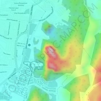
Name: Gunung Ayer Hangat topographic map, elevation, terrain.
Location: Gunung Ayer Hangat, Ipoh, Kinta, Perak, 31150, Malaysia (4.62953 101.16025 4.62963 101.16035)
Average elevation: 128 m
Minimum elevation: 21 m
Maximum elevation: 393 m
Thank you for supporting this site ❤️
Make a donation
Make a donation
Other topographic maps
Click on a map to view its topography, its elevation and its terrain.
Thank you for supporting this site ❤️
Make a donation
Make a donation
Thank you for supporting this site ❤️
Make a donation
Make a donation