
Thank you for supporting this site ❤️
Make a donation
Make a donation
Gandaki topographic map
Click on the map to display elevation.
Thank you for supporting this site ❤️
Make a donation
Make a donation
About this map
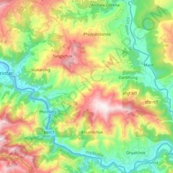
Name: Gandaki topographic map, elevation, terrain.
Location: Gandaki, गोरखा, गण्डकी प्रदेश, Nepal (27.79556 84.63276 27.92836 84.78259)
Average elevation: 801 m
Minimum elevation: 254 m
Maximum elevation: 1,690 m
Thank you for supporting this site ❤️
Make a donation
Make a donation
Other topographic maps
Click on a map to view its topography, its elevation and its terrain.
Thank you for supporting this site ❤️
Make a donation
Make a donation
Thank you for supporting this site ❤️
Make a donation
Make a donation
Mount Everest
Nepal > कोशी प्रदेश > सोलुखुम्बु
In de negentiende eeuw werd de toenmalige kolonie Brits-Indië in kaart gebracht bij de Great Trigonometrical Survey en in 1856 werd de hoogte vastgesteld. De Britten konden toen niet bij de berg komen, maar berekenden door driehoeksmeting vanaf 150 kilometer afstand de hoogte en zaten er maar acht meter naast.
Average elevation: 7,850 m
Thank you for supporting this site ❤️
Make a donation
Make a donation
Thank you for supporting this site ❤️
Make a donation
Make a donation