
Make a donation
Kāmrūp topographic map
Click on the map to display elevation.
Make a donation
About this map
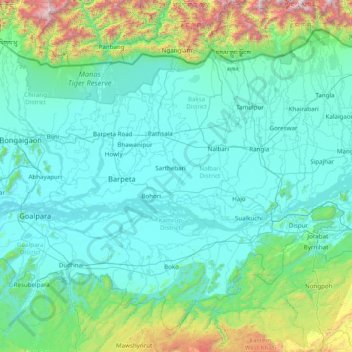
Name: Kāmrūp topographic map, elevation, terrain.
Location: Kāmrūp, Barpeta District, Assam, 781307, India (25.63333 90.55000 27.03333 91.95000)
Average elevation: 330 m
Minimum elevation: 24 m
Maximum elevation: 2,793 m
Make a donation
Other topographic maps
Click on a map to view its topography, its elevation and its terrain.
Kaziranga National Park and Tiger Reserve
The park is approximately 40 km (25 mi) in length from east to west, and 13 km (8 mi) in breadth from north to south. Kaziranga covers an area of 378 km2 (146 sq mi), with approximately 51.14 km2 (20 sq mi) lost to erosion in recent years. A total addition of 429 km2 (166 sq mi) along the present boundary of…
Average elevation: 202 m
Make a donation
Make a donation
Make a donation
South Salmara-Mankachar
South Salmara Mankachar district occupies an area of 568 square kilometres (219 sq mi). It occupies 980/km 2 (2,500/sq mi) of density and is an administrative district in the state of Assam in India. The district headquarters are located at Hatsingimari town which is situated at about 245 km from Guwahati, the…
Average elevation: 58 m
Make a donation
Make a donation