
Thank you for supporting this site ❤️
Make a donation
Make a donation
Alo topographic map
Click on the map to display elevation.
Thank you for supporting this site ❤️
Make a donation
Make a donation
About this map
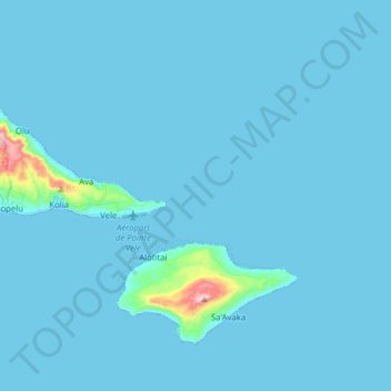
Name: Alo topographic map, elevation, terrain.
Location: Alo, Wallis and Futuna, 98610, France (-14.36218 -178.15743 -14.24619 -178.00011)
Average elevation: 14 m
Minimum elevation: 0 m
Maximum elevation: 408 m
Thank you for supporting this site ❤️
Make a donation
Make a donation
Other topographic maps
Click on a map to view its topography, its elevation and its terrain.
Thank you for supporting this site ❤️
Make a donation
Make a donation
Thank you for supporting this site ❤️
Make a donation
Make a donation
Thank you for supporting this site ❤️
Make a donation
Make a donation