
Make a donation
Montgomery County topographic map
Click on the map to display elevation.
Make a donation
Montgomery County
Montgomery County features a predominantly flat terrain, with average elevations ranging from about 100 to 350 feet above sea level. The landscape is gently rolling, particularly towards the northern areas, and is interspersed with several lakes, such as the expansive Lake Conroe. This large reservoir, formed by the damming of the West Fork of the San Jacinto River, is a key topographical feature of the county. The area is dotted with wetlands and minor ridges, contributing to a mix of forested regions and open plains. While most of the county remains below 300 feet in elevation, it exhibits subtle variations in terrain, particularly near the lake and in parts of the Sam Houston National Forest.
Make a donation
About this map
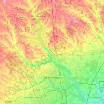
Name: Montgomery County topographic map, elevation, terrain.
Location: Montgomery County, Texas, United States (30.02605 -95.83016 30.63042 -95.09665)
Average elevation: 69 m
Minimum elevation: 13 m
Maximum elevation: 147 m
Make a donation
Other topographic maps
Click on a map to view its topography, its elevation and its terrain.
Make a donation
Make a donation
Georgetown
United States > Texas > Georgetown
The city is located on the northeastern edge of Texas Hill Country. Portions of Georgetown are located on either side of the Balcones Escarpment, a fault line in which the areas roughly east of IH-35 are flat and characterized by having black, fertile soils of the Blackland Prairie, and the west side of the…
Average elevation: 219 m
Make a donation
Make a donation
Make a donation
Make a donation
Make a donation
Make a donation
Make a donation
Make a donation
Enchanted Rock
United States > Texas > Llano County
Enchanted Rock is a pink granite mountain located in the Llano Uplift about 17 miles (27 km) north of Fredericksburg, Texas and 24 miles (39 km) south of Llano, Texas, United States. Enchanted Rock State Natural Area, which includes Enchanted Rock and surrounding land, spans the border between Gillespie and…
Average elevation: 453 m
Make a donation
Padre Island National Seashore
United States > Texas > Kenedy County > Corpus Christi
Average elevation: 5 m
Make a donation
Make a donation
Make a donation
Make a donation
Make a donation
Make a donation
Make a donation
Make a donation
Make a donation
Make a donation
Choke Canyon State Park - Calliham Unit
United States > Texas > McMullen County > Calliham
Average elevation: 67 m
Make a donation
Make a donation
Mineral Wells Fossil Park
United States > Texas > Palo Pinto County > Mineral Wells
Average elevation: 283 m
Make a donation
Rio Vista Addition Colonia
United States > Texas > El Paso County > Socorro
Average elevation: 1,116 m
Make a donation