
Thank you for supporting this site ❤️
Make a donation
Make a donation
Moorefield topographic map
Click on the map to display elevation.
Thank you for supporting this site ❤️
Make a donation
Make a donation
About this map
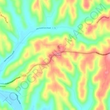
Name: Moorefield topographic map, elevation, terrain.
Location: Moorefield, Harrison County, Ohio, 43985, United States (40.17979 -81.19094 40.21979 -81.15094)
Average elevation: 319 m
Minimum elevation: 268 m
Maximum elevation: 382 m
Thank you for supporting this site ❤️
Make a donation
Make a donation
Other topographic maps
Click on a map to view its topography, its elevation and its terrain.
Thank you for supporting this site ❤️
Make a donation
Make a donation
Thank you for supporting this site ❤️
Make a donation
Make a donation