
Thank you for supporting this site ❤️
Make a donation
Make a donation
Freeport topographic map
Click on the map to display elevation.
Thank you for supporting this site ❤️
Make a donation
Make a donation
About this map
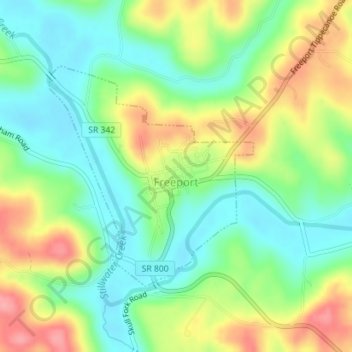
Name: Freeport topographic map, elevation, terrain.
Location: Freeport, Harrison County, Ohio, United States (40.20261 -81.27898 40.21950 -81.25843)
Average elevation: 301 m
Minimum elevation: 260 m
Maximum elevation: 363 m
Thank you for supporting this site ❤️
Make a donation
Make a donation
Other topographic maps
Click on a map to view its topography, its elevation and its terrain.
Thank you for supporting this site ❤️
Make a donation
Make a donation
Thank you for supporting this site ❤️
Make a donation
Make a donation