
Make a donation
Peru topographic map
Click on the map to display elevation.
Make a donation
Peru
Peru's topography is strikingly diverse, shaped by the Andes mountain range that runs through the center of the country, splitting the landscape into three distinct regions: the coastal desert, the Andean highlands, and the Amazon basin. The coastal region is marked by arid, desert-like terrain, with dramatic cliffs and dunes along the Pacific Ocean. To the east, the Andes rise sharply, with towering peaks exceeding 20,000 feet, and plateaus such as the Altiplano that include high-altitude cities like Puno. The mountains create dramatic elevations, giving rise to varied microclimates, from freezing glacial zones to warmer, cloud-forests. On the eastern slopes, the land drops into the Amazon basin, a vast tropical rainforest filled with meandering rivers and dense vegetation. The geography not only influences the climate, leading to everything from humid jungle to alpine conditions, but it also shapes the culture and economy, with agricultural terraces and diverse ecosystems supporting life at every elevation.
Make a donation
About this map
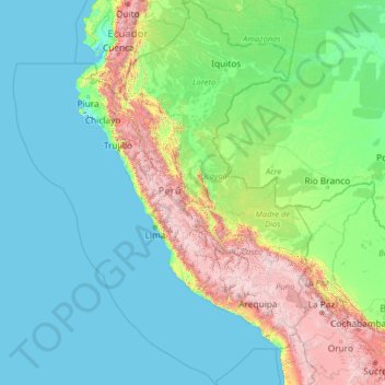
Name: Peru topographic map, elevation, terrain.
Location: Peru (-20.19845 -84.63565 -0.03928 -68.65199)
Average elevation: 645 m
Minimum elevation: -3 m
Maximum elevation: 6,020 m
Make a donation
Other topographic maps
Click on a map to view its topography, its elevation and its terrain.
Make a donation
Africa
Africa's topography is a complex tapestry of plateaus, mountains, valleys, and deserts. The continent is dominated by vast plateaus, with elevations averaging around 1,000 meters (3,281 feet), especially prominent in the south and east. The Ethiopian Highlands, often referred to as the "Roof of Africa," rise…
Average elevation: 462 m
Make a donation
Fort Canning Park
The hill has a long history intertwined with that of the country due to its location as the highest elevation within walking distance to the city's civic district, within the Downtown Core. It is also a popular location for exhibitions, concerts, and outdoor recreation.
Average elevation: 19 m
Make a donation
Make a donation
Make a donation
Make a donation
Debre Markos
Ethiopia > Amhara Region > Guzamn
Debre Markos is located 300 km north-west of Addis Ababa along the Addis Ababa-Gondar road at an elevation of over 2400 meters.
Average elevation: 2,343 m
Make a donation
Make a donation
Make a donation
Make a donation
Make a donation
Kotdwar
India > Uttarakhand > Kotdwara
Kotdwar lies on the western margin of the Himalayas, at an altitude of 454 m (1,490 ft) above sea level.
Average elevation: 641 m
Make a donation
Sinabad
Iran > West Azerbaijan Province > Urumia County > دهستان صومای جنوبی
Average elevation: 1,876 m
Make a donation
Make a donation
Aramoun
Lebanon > Mount Lebanon Governorate
Aramoun (Arabic: عرمون) is a village in the Aley District of Mount Lebanon, Lebanon, lying to the east of Khalde and 22 kilometres away from Beirut. Aramoun's altitude ranges between 250 meters to 600 meters further east. The village has a Druze and Christian community, major families are Yehia, Jawhari,…
Average elevation: 467 m
Make a donation
Corró d'Amunt
Spain > Catalonia > Vallès Oriental > les Franqueses del Vallès
Average elevation: 287 m
Make a donation
Pièce du Moulin
France > Nouvelle-Aquitaine > Charente-Maritime > Le Grand-Village-Plage
Average elevation: 4 m
Make a donation
Make a donation
Make a donation
Make a donation
San Jose
The municipality is in a valley bounded on the east by the Palusong Mountain Range moving south and on the west by the Hitaasan Mountain Range. The land is generally alluvial flat and swamplands which has an elevation of less than 10 metres (33 ft) above sea level, while going south, south easterly, the…
Average elevation: 15 m
Make a donation
Make a donation
Αβία
Greece > Peloponnese Region > Messenia Regional Unit > Municipal Unit of Avia
Average elevation: 45 m
Make a donation
Make a donation
Johannesburg
South Africa > Gauteng > City of Johannesburg Metropolitan Municipality
Johannesburg is located in the eastern plateau area of South Africa known as the Highveld, at an elevation of 1,753 metres (5,751 ft). The former Central Business District is located on the southern side of the prominent ridge called the Witwatersrand (English: White Water's Ridge) and the terrain falls to the…
Average elevation: 1,615 m
Lindridge Park
United Kingdom > England > Devon > Teignbridge > Luton > Humber
Average elevation: 125 m
Worsbrough
United Kingdom > England > Barnsley
On High Street, Worsbrough Dale. The east elevation bears the inscriptions "AD 1903" and "Ebenezer Wesleyan Reform". There are also foundation stones either side of the doorway inscribed with "EBENEZER CHAPEL 1854". This suggests that the chapel was built in 1854 and extended upwards in 1903.
Average elevation: 98 m
Make a donation