
Make a donation
Kedarkantha topographic map
Click on the map to display elevation.
Make a donation
Kedarkantha
Kedarkantha is a mountain peak of the Himalayas in Uttarakhand, India. Its elevation is 12,500 ft (3,800 m). Kedarkantha is located within Govind Wildlife Sanctuary in Uttarkashi district.
Make a donation
About this map
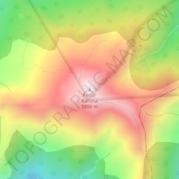
Name: Kedarkantha topographic map, elevation, terrain.
Location: Kedarkantha, Mori, Uttarkashi, India (31.02248 78.17185 31.02258 78.17195)
Average elevation: 3,404 m
Minimum elevation: 2,947 m
Maximum elevation: 3,811 m
Make a donation
Other topographic maps
Click on a map to view its topography, its elevation and its terrain.
Chennai District
Chennai district covers an area of 426 km2 located on the Eastern Coastal Plains of India. It is situated on the northeastern corner of Tamil Nadu along the Coramandel coast, a region bounded by the Bay of Bengal and is surrounded inland by the districts of Tiruvallur, Kanchipuram and Chengalpattu. It lies…
Average elevation: 9 m
Make a donation
Ernakulam district
The Ernakulam district covers an area of 3,068 km2 (1,185 sq mi) on the Western Coastal Plains of India. It is surrounded by the Thrissur District to the north, the Idukki District to the east, Alappuzha and Kottayam districts to the south and the Laccadive Sea to the west. The Anamalais occupy a large part of…
Average elevation: 201 m
Make a donation
Make a donation
Kasaragod district
The district is the northernmost district of the State of Kerala. Kasargod is located at 12°30′N 75°00′E / 12.5°N 75.0°E / 12.5; 75.0. It has an average elevation of 19 metres (62 feet). Ranipuram or Madathumala (1016m) peak is the highest peak in the Kasargod district of Kerala, located in…
Average elevation: 127 m
Coimbatore District
Apart from the species common to the plains, wild elephants, wild boars leopards, tigers, bison, species of deer, Nilgiri tahr, sloth bear and black-headed oriole can be found. The Anamalai Wildlife Sanctuary 88 km (55 mi) in the Western Ghats at an altitude of 1,400 meters covers an area of 958 km2. More than…
Average elevation: 551 m
Kozhikode district
Kozhikode district is bordered by the districts of Kannur and Mahé (Puducherry) to the north, Wayanad to the east, and Malappuram to the south. The Arabian Sea lies to the west and Western Ghats stretches towards east. Vavul Mala, a 2,339 m high peak situated on the trijunction of Kozhikode, Malappuram, and…
Average elevation: 295 m
Make a donation
Barren Island
India > Andaman and Nicobar Islands
This volcanic island stands in the midst of a volcanic belt on the edge of the Indian and Burmese tectonic plates. Narcondam Island is a dormant volcano in the area, apart from volcanic seamounts like Alcock and Sewell. All the historical and recent eruptions (1789 and after) are confined within and around an…
Average elevation: 108 m
ChengiCherla Cheruvu aka Pochamma Kunta
India > Telangana > Medipally mandal > Chengicherla
Average elevation: 510 m
Make a donation
Wokha
It covers an area of 1,628 sq. km. which equals around 9.82% of the total area of Nagaland. Of the total area, 35.74% comes under subtropical hill zone, 23.64% under subtropical plain zone and 40.59% in the mild tropical hill zone. The average altitude of the Wokha (Upper Range) is 1000-1500m above sea level;…
Average elevation: 466 m
Make a donation
Shikari Devi Wildlife Sanctuary
India > Himachal Pradesh > Thunag > Sangalwara
Average elevation: 2,518 m
Make a donation
Make a donation
Make a donation
Make a donation
Make a donation
Make a donation
Make a donation
Make a donation
Palasa
Palasa has an average elevation of 38 meters (127 feet). The town has an area of 32.75 km2 (12.64 sq mi).
Average elevation: 76 m
Make a donation
Make a donation
Make a donation
Make a donation
Make a donation
Make a donation
Make a donation
Make a donation
Make a donation
Arcot
India > Tamil Nadu > Arcot
Arcot is located at 12°54′N 79°20′E / 12.9°N 79.33°E / 12.9; 79.33. It has an average elevation of 164 metres (538 ft).
Average elevation: 169 m
Make a donation
Make a donation