
Make a donation
Tingo María topographic map
Click on the map to display elevation.
Make a donation
Tingo María
Tingo María was considered unreachable until 1936, when the Montaña Road reached the settlement. It was then that the state run Estacion Experimental Agricola was established due to its "comfortable" elevation (2,204 ft). In 1942, the U.S. Government began adding more funding to the station, and by 1960 over 40,000 acres (160 km2) of land were under cultivation, especially along the Huallaga River valley where land was level. Coffee was a particularly valuable crop. The city nickname is "the Door of the Amazonia."
Make a donation
About this map
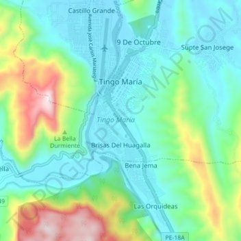
Name: Tingo María topographic map, elevation, terrain.
Location: Tingo María, Province of Leoncio Prado, Huánuco, Peru (-9.34403 -76.01584 -9.27528 -75.98359)
Average elevation: 841 m
Minimum elevation: 632 m
Maximum elevation: 1,472 m
Make a donation
Other topographic maps
Click on a map to view its topography, its elevation and its terrain.
La Bella Durmiente
La Bella Durmiente (Spanish for Sleeping Beauty), also known as Puma Ringri (possibly from Quechua puma cougar, puma, rinri ear, "puma ear"), is a mountain and prominent feature of Tingo María National Park, in the region of Huánuco, Peru. It is located in the district of Mariano Damaso, Leoncio Prado…
Average elevation: 877 m
Make a donation
Make a donation
Make a donation
Make a donation
Tingo Maria National Park
Peru > Huánuco > Mariano Dámaso Beraún
Topography in the park is steep and mountainous, because the Bella Durmiente massif occupies almost of its entire extension. Elevations in the park are in the range of 650–1808 m; rocky walls of 300–500 m in height are common. Soils are calcareous, rocky and thin, and landslides due to natural causes or…
Average elevation: 1,136 m
Make a donation