
Thank you for supporting this site ❤️
Make a donation
Make a donation
Florida topographic map
Click on the map to display elevation.
Thank you for supporting this site ❤️
Make a donation
Make a donation
About this map
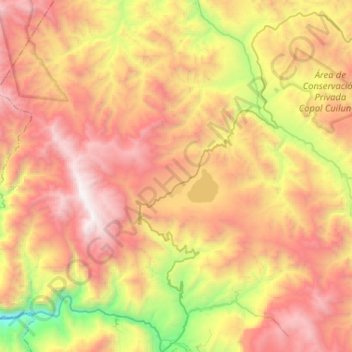
Name: Florida topographic map, elevation, terrain.
Location: Florida, Province of Bongará, Amazonas, Peru (-5.89039 -78.10229 -5.74026 -77.84234)
Average elevation: 2,265 m
Minimum elevation: 873 m
Maximum elevation: 3,545 m
Thank you for supporting this site ❤️
Make a donation
Make a donation
Other topographic maps
Click on a map to view its topography, its elevation and its terrain.