
Puketāpapa topographic map
Interactive map
Click on the map to display elevation.
About this map
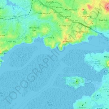
Name: Puketāpapa topographic map, elevation, terrain.
Location: Puketāpapa, Auckland, Nouvelle-Zélande (-36.98924 174.68320 -36.89485 174.77546)
Average elevation: 22 m
Minimum elevation: -2 m
Maximum elevation: 164 m
Other topographic maps
Click on a map to view its topography, its elevation and its terrain.
Muriwai
Nouvelle-Zélande > Auckland > Rodney
Muriwai, Rodney, Auckland, 0881, Nouvelle-Zélande
Average elevation: 63 m
Saint Heliers
Nouvelle-Zélande > Auckland > Ōrākei
Saint Heliers, Ōrākei, Auckland, 1074, Nouvelle-Zélande
Average elevation: 16 m
Auckland
Auckland, Waitematā, Auckland, 1010, Nouvelle-Zélande
Average elevation: 32 m
Omaha Beach
Nouvelle-Zélande > Auckland > Rodney > Omaha
Omaha Beach, Omaha, Rodney, Auckland, Nouvelle-Zélande
Average elevation: 3 m
Île de la Petite Barrière
Nouvelle-Zélande > Auckland > Aotea Great Barrier
Île de la Petite Barrière, Aotea Great Barrier, Auckland, Nouvelle-Zélande
Average elevation: 145 m
Waitakere Ranges Regional Park
Nouvelle-Zélande > Auckland > Waitākere Ranges
Waitakere Ranges Regional Park, Cornwallis, Waitākere Ranges, Auckland, Nouvelle-Zélande
Average elevation: 7 m
Rotoroa Island
Nouvelle-Zélande > Auckland > Waiheke
Rotoroa Island, Waiheke, Auckland, Nouvelle-Zélande
Average elevation: 2 m
Waitematā
Nouvelle-Zélande > Auckland > Waitematā
Waitematā, Auckland, Nouvelle-Zélande
Average elevation: 32 m
Rangitoto Island
Nouvelle-Zélande > Auckland > Waiheke
Rangitoto Island, Waiheke, Auckland, Nouvelle-Zélande
Average elevation: 30 m