
Bulgaria topographic map
Interactive map
Click on the map to display elevation.
Bulgaria
Bulgaria is a small country situated in Southeastern Europe, in the east of the Balkans. Its territory covers an area of 110,994 square kilometres (42,855 sq mi), while land borders with its five neighbouring countries run a total length of 1,808 kilometres (1,123 mi), and its coastline is 354 kilometres (220 mi) long. Bulgaria's geographic coordinates are 43° N 25° E. The most notable topographical features of the country are the Danubian Plain, the Balkan Mountains, the Thracian Plain, and the Rila-Rhodope massif. The southern edge of the Danubian Plain slopes upward into the foothills of the Balkans, while the Danube defines the border with Romania. The Thracian Plain is roughly triangular, beginning southeast of Sofia and broadening as it reaches the Black Sea coast.
About this map
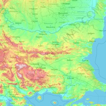
Name: Bulgaria topographic map, elevation, terrain.
Location: Bulgaria (41.23537 22.35715 44.21622 28.88754)
Average elevation: 300 m
Minimum elevation: -3 m
Maximum elevation: 2,750 m
Other topographic maps
Click on a map to view its topography, its elevation and its terrain.
Daveyton
South Africa > Gauteng > City of Ekurhuleni Metropolitan Municipality
Average elevation: 1,613 m
Kuala Lumpur
Located in the centre of Selangor state, Kuala Lumpur was a territory of Selangor State Government. In 1974, Kuala Lumpur was split off from Selangor to form the first Federal Territory governed directly by the Malaysian federal government. Its location in the most developed state on the west coast of…
Average elevation: 127 m
Kotagiri
India > Tamil Nadu > Kotagiri
Kotagiri is a hill station and a municipality in the Nilgiris district of the Indian state, Tamil Nadu. The Nilgiri hills have been the traditional home of the "Kota" tribes. The name 'Kota-giri' itself means 'mountains of the kotas'. Kotagiri was known in the past as 'Kota-keri' or 'Kota-gherry', the 'street…
Average elevation: 1,781 m
Bothaville
South Africa > Free State > Lejweleputswa District Municipality > Nala Local Municipality
Average elevation: 1,287 m
Stellenbosch
South Africa > Western Cape > Cape Winelands District Municipality > Stellenbosch Local Municipality
Stellenbosch is 53 km (33 mi) east of Cape Town via National Route N1. Stellenbosch is in a hilly region of the Cape Winelands, and is sheltered in a valley at an average elevation of 136 m (446 ft), flanked on the west by Papegaaiberg (Afrikaans: Parrot Mountain), which is actually a hill. To the south is…
Average elevation: 222 m
Moulin de la Locherie
France > Nouvelle-Aquitaine > Haute-Vienne > Oradour-Saint-Genest
Average elevation: 201 m
Scafell Pike
United Kingdom > England > Cumberland
Scafell Pike (/ˈskɔːfɛl/) is a mountain in the Lake District region of Cumbria, England. It has an elevation of 978 metres (3,209 ft) above sea level, making it the highest and the most prominent mountain in England. The mountain is part of the Scafell massif, an extinct volcano, and is one of the Southern…
Average elevation: 679 m
Kampung Indian Settlement Batu Caves
Malaysia > Selangor > Selayang Municipal Council > Batu Caves
Average elevation: 68 m
Kodaikanal
India > Tamil Nadu > Kodaikanal
Kodaikanal (Tamil: [ko'ɖaɪ'kaːnəl]) (English: ko-DYE-KAH-null) is a municipality and hill station in Dindigul district in the state of Tamil Nadu, India. It is situated at an altitude of 2,225 m (7,300 ft) in the Palani hills of the Western Ghats. Kodaikanal was established in 1845 to serve as a refuge…
Average elevation: 1,976 m
La Guérite
France > Nouvelle-Aquitaine > Haute-Vienne > Maisonnais-sur-Tardoire
Average elevation: 248 m
Doha
Doha is located on the central-east portion of Qatar, bordered by the Persian Gulf on its coast. Its elevation is 10 m (33 ft). Doha is highly urbanized. Land reclamation off the coast has added 400 hectares of land and 30 km of coastline. Half of the 22 km² of surface area which Hamad International Airport…
Average elevation: 12 m