
Kollam topographic map
Interactive map
Click on the map to display elevation.
Kollam
Kollam district (formerly Quilon) is one of 14 districts of the state of Kerala, India. The district has a cross-section of Kerala's natural attributes; it is endowed with a long coastline, a major Laccadive Sea seaport and an inland lake (Ashtamudi Lake). The district has many waterbodies. Kallada River is one among them, and the east side land of river is EastKallada and the west side land is WestKallada. Kallada Boat race is one among the famous festival events of district. Even though it is a competition between two land sides of the river, many boat clubs from various place,s even beyond the district participate in the event. Kollam is the capital of Kerala's cashew industry. Plains, mountains, lakes, lagoons and backwaters, forests, farmland and rivers make up the topography of the district. The area had trading relationships with Phoenicia and Ancient Rome.
About this map
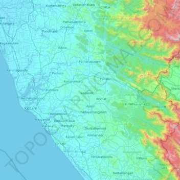
Name: Kollam topographic map, elevation, terrain.
Location: Kollam, Kerala, India (8.76014 76.47647 9.17404 77.25937)
Average elevation: 198 m
Minimum elevation: -1 m
Maximum elevation: 1,824 m
Other topographic maps
Click on a map to view its topography, its elevation and its terrain.
Kannur
Kannur has an elevation of 1.02 metres or 3.3 feet along the coast of the Laccadive Sea, with a sandy coastal area. The city has an 8 kilometres (5.0 mi)-long seashore and a 3 kilometres (1.9 mi)-long beach at Payyambalam. Kannur is located north of Kozhikode, south of Kasargod and Mangalore, west of the…
Average elevation: 14 m
Ernakulam
India > Kerala > Kanayannur
The Ernakulam District is situated in Central Kerala in India. Ernakulam is located at the geographic coordinates of 9°58′53.8″N 76°17′59.6″E / 9.981611°N 76.299889°E / 9.981611; 76.299889 and at an elevation of 22.36 m (73.4 ft) above the mean sea level.
Average elevation: 6 m
Elappara
Elappara is a village in Idukki district in the Indian state of Kerala. It is one of the panchayaths in Peerumedu taluk. The area is marked by a cool climate as the region is situated at an elevation of more than 1,000 m (3,300 ft) above the sea level. Elappara is famous for its vast tea plantations.
Average elevation: 1,049 m
Mannarkkad
Mannarkkad is located at 10°59′N 76°28′E / 10.98°N 76.47°E / 10.98; 76.47. It has an average elevation of 76 m (249 ft). Mannarkkad is located 36 km north-west of district headquarters Palakkad, along National Highway 966 and 100 km north west of Kozhikode. Mannarkkad is located in the…
Average elevation: 80 m
Adimali
Adimaly generally has a cool climate throughout the year, typical of the higher altitudes, though not as cold as Munnar. Temperatures rarely exceed 26 degrees and never drop below 10 degrees as it usually stays around 17-24 degrees. Though December–January are comparatively cooler than other months. Adimaly…
Average elevation: 786 m
Piravom
India > Kerala > Muvattupuzha
Piravom was reverted to panchayat status in 1992 after two years as a municipality because of skepticism that its classification as a municipality would attract higher tax rates and building regulation. However, as modern municipal councils now have the authority to fix the tax rate and new building rule…
Average elevation: 23 m